|
tap row or icons for details
|
| Difficulty |
|
3 of 5 |
| Route Finding |
|
3 of 5 |
| Distance Round Trip |
|
3.6 miles |
| Trailhead Elevation |
|
6,245 feet |
| Elevation Gain |
|
431 feet |
| Accumulated Gain |
|
800 feet |
| Kokopelli Seeds |
|
7.6 |
| Interest Off-Trail Hiking & Peak | | unreported if dogs are allowed
editedit > ops > dogs to adjust |
| | |
|
|
11 |
2022-11-27 | DixieFlyer |
|
|
4 |
2016-05-14 | topohiker |
|
|
10 |
2016-03-05 |
Picture - Bear Head - Copper Mountain |
The_Eagle |
|
|
|
8 |
2016-03-05 |
Picture - Bear Head - Copper Mountain |
joebartels |
|
|
|
9 |
2015-09-07 |
Dupont Cabin / Copper Mountain |
topohiker |
|
|
|
14 |
2015-08-22 | BEEBEE |
|
|
50 |
2012-10-07 | CannondaleKid |
|
| |
|
|
list |
map |
done |
Globe Region |
| | |
|
| |
|
|
Historical Weather |
| Trailhead Forecast | | |
|
 |
|
|
| Preferred Oct, Apr, May, Mar |
|
|
| | |
Named Locations Coordinate Links
| |
|
|
Copper Mountain - Copper Mtn Quad
|
3.05 mi
763 ft |
 |
| Copper Mountain - Copper Mtn Quad
|
24.25 mi
4,914 ft |
|
|
| Picture - Bear Head - Copper Moun...
|
20.66 mi
3,326 ft |
|
|
| Picture - Bear Head - Copper Moun...
|
21.01 mi
3,421 ft |
|
|
| | |
| |
|
|
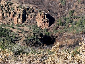
Overview: Copper Mountain is located in the Copper Mountain Quadrangle in Gila County. With a rise of 1056' and an elevation of 6676' its Arizona Peaks Rank is 1017. Its summit coords are: 33.9253 -111.1014
|
 Route Editor