Route Editor

| Guide | ♦ | 2 Triplogs | 0 Topics |
details | drive | permit | forecast | route |
stats |
photos | triplogs | topics | location |
| 25 | 2 | 0 |
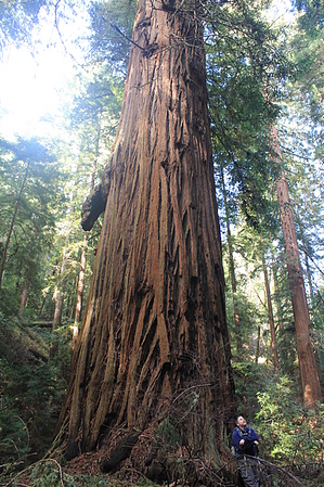
Lots Of Old Growth Redwoods by JimmyLyding Portola State Park is 2,800 acres of mainly typical coast redwood forest with a few grassy ridgelines lying 1,000' below the crest of the central Santa Cruz Mountains west of the lovely town of Woodside. This hike stays a few hundred feet above the drainage bottoms for most of the hike, and features a dense mix of redwood, Douglas fir, California bay, some live oak, and the various ferns and understory found in these woods. Leave your sunglasses and sunscreen behind, and be surprisingly disappointed by the low quality of your photographs despite the scenery because this hike goes through a deep, dark forest with some of the tallest trees on earth.
From the parking area(s) take the signed trail to the Slate Creek Trail / Old Tree Trail. Old Tree branches off to the right / east after about 100 yards while you continue on to Slate Creek Trail 1/2 mile and 200' ahead. Go right / east on the Slate Creek Trail towards Slate Creek Trail Camp for 2 miles of relatively flat hiking on a smooth trail through a forest mainly consisting of 50-100' redwoods and broadleaf evergreens. This area was extensively logged around the turn of the 20th Century, but these woods are making a strong comeback. Slate Creek Trail Camp has a porta-potty and 6 camping sites (no fires allowed). Look for the ridiculous sign 20 yards uphill and to the left and north of the porta-potty that warns of a difficult 7-mile hike to Peters Grove and back, and ignore it while continuing past it on the Bear Creek Trail. This route has already traveled over 500' AEG to this point, and the next stretch adds enough to make you earn a 1,000' ascent over the first 4.25 miles. This stretch passes the remains of an old settlement (or hobo camp, you be the judge) after a picturesque old car wreck on the right with a few open areas before traveling through a dense, young forest to the high point of the hike at around 1,450'. Bay and tanoak trees reach 20-30' providing a nice mix of light and shade on the climb uphill. The Bear Creek Trail quickly plunges downhill for about 1.5 miles to the confluence of Peters and Bear creeks. This stretch is memorable not only for its nice views down into the Peters Creek drainage, but the sense of foreboding of knowing that one has to climb back out on the same trail. The last 1/2 mile to the junction of Bear and Peters creeks is very dark. It's one of the darkest redwood forests I've ever seen in the Bay Area, and I've seen pretty much all of them. The trees here are huge, absolutely huge. Forget taking pictures unless you're an advanced photographer with a tripod. Marvel at the ginormous trees, and cross the creek while following the sign to Peters Creek Loop. The trail winds around a drainage about 100' to the north of Bear Creek before reaching its junction with the loop. Head right up Peters Creek for a few hundred yards through a nice redwood forest before dropping 50' down to the creek bottom. The trail crosses Peters Creek in front of a large redwood that is growing on the cliff just above the creek. Crossing would be hazardous after heavy rainfall, but not insurmountable most of the time. You are now on the Peters Creek Loop Trail, and it heads uphill and west / downhill along Peters Creek for about 1/3 mile before crossing back over and forming a loop back at its junction with the Bear Creek Trail. Return the way you came while enjoying the steep 800' uphill climb to the high point before returning to the parking lot. The junction with the Summit Trail is at the junction a mile from the parking lot along the original route, and is a steeper but shorter way down to the end of Portola State Park Rd. It requires a 1/3 mile walk back to the parking lot(s). Check out the Official Route and Triplogs. Leave No Trace and +Add a Triplog after your hike to support this local community. | ||||||||||||||||||||||||||||||||||||||||||||||||||||||||||||||||||||||||||||||||||