Carson Pass is a paved trailhead with a visitor center situated on Highway 88 in Alpine county, California. It is a very popular trailhead as not only does it access dozens of day hike destinations but the Pacific Crest Trail(PCT) passes thru allowing backpackers to re supply. Carson Pass is named for Kit Carson, a colorful explorer who opened up this passage in 1844 and had carved his name and date on a tree at this location.
Overnight stays or campfires require a permit which can be obtained at the trailhead in summer months. There is a five dollar exact change day use fee to park in the often crowded parking lot. Self pay booths are on site and there is overflow parking just west and across the street.
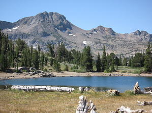
The hike to Frog Lake starts alongside the visitor center. Several interpretive placards and maps lay out the Mokelumne wilderness destinations that lie ahead. Frog Lake is the shortest of these destinations and offers a family friendly hike with a wilderness twist. It is quite likely in this first mile that you will encounter seasoned backpackers loaded for extended trips on the trail, many who are more than willing to talk and share some stories of their adventures. The trail enters a wooded section in an area with large granite boulders lining the trail. The slope is gentle but there is no doubt in the elevation gain in this first mile. The trail is often lined with wild flowers in July and August and there are several creeks to cross. Watch for the many deformed trees caused by the tremendous snowfalls each year. Soon the horizon opens up with views of distant mountains. As you emerge from the forest shade is never too far away as there are large trees consistently along this trail. When you arrive at an unmarked Y intersection look over your left shoulder to see Frog Lake. Take the left trail to Frog Lake and take the interesting loop around the lake. It can be accomplished in either direction. This is a glacier formed lake and fed by snow melt. In the later part of summer the lake begins to dry up. It is a great time to get your feet wet or go for a swim. On the northeast side of the lake is a great viewpoint looking down on the valleys to the east and Red Lake far below. You can also get a glimpse of highway 88 and the cars working there way up the mountain letting you know civilization is not all that far away. A picnic lunch might be the ticket before you return the way you came.
WARNING! Hiking and outdoor related sports can be dangerous. Be responsible and prepare for the trip. Study the area you are entering and plan accordingly. Dress for the current and unexpected weather changes. Take plenty of water. Never go alone. Make an itinerary with your plan(s), route(s), destination(s) and expected return time. Give your itinerary to trusted family and/or friends.
Permit $$
information is in description
Directions
Road
Paved - Car Okay
To Carson Pass Trailhead The trailhead is located at the Carson Pass Visitor Center. Highway 88, 30 miles west of Minden, Nevada.
$5.00 day use parking fee-exact change-honor system. Overnight parking is allowed, make sure you have paid for more than one night. Permit required for overnight stay.
 Route Editor