username
X
password
register
for free!
help


Dana Point Marine Life Refuge, CA

Guide 1 Triplog  0 Topics
  5 of 5  
Fav
Wish
0
details
drive
no permit
forecast
map
stats
photos
triplog
topics
location
0 1 0
Statistics
tap row or icons for details
Difficulty 1 of 5
Distance One Way 1.5 miles
Trailhead Elevation 215 feet
Elevation Gain 100 feet
Accumulated Gain 200 feet
Kokopelli Seeds 2.17
 Dogs not allowed
feature photo
Photos Viewed All MineFollowing
80  2013-02-01
Dana Point Whale Watching Trek - Feb2013
Randal_Schulhaus
Author
author avatar Guides 16,843
Routes 17,472
Photos 24
Trips 1 map ( 6 miles )
Age 28 Male Gender
Location HAZ, TrailDEX
Associated Areas
list map done
Orange Region
Historical Weather
Trailhead Forecast
Expand Map
Preferred Jan, Feb, Dec, Mar
Sun  5:27am - 6:11pm
0 Route
 
0 Alternative


Overview: The Dana Point Marine Life Refuge is an intertidal habitat filled with an amazing variety of marine life. The refuge extends from Strands Beach all the way to Dana Point Harbor.


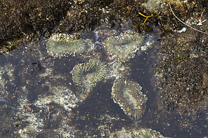
Visitors can walk along the rocky beach, explore sea caves, study ancient earthquake faults and discover an abundant amount of sea life at the public tidepool exhibit.
remove free decal offer
The refuge is a perfect family outing, where children and can learn how to respect the ocean habitat and all the creatures that depend on it for life.

At low tide, visitors to the Dana Point Marine Life Refuge can observe sea anemones, star fish, octopus, shell fish and more. You might even be able to see dolphins farther out past the break lines.

Visitors are asked to treat the sea life gently. This means never picking up or stepping on live animals and plants. You can access the refuge by parking at the Ocean Institute and following the paved path to the beach shore.

The "upper refuge" has an interpretive center and parking for about 15 vehicles.

Exploring the Marine Life Refuge is sure to work up an appetite. Dana Point includes many great restaurants as well as boutique shopping.

2018-07-14 HAZ_Hikebot


    Check out the Triplog.
    Leave No Trace and +Add a Triplog after your hike to support this local community.

    One-Way Notice
    This hike is listed as One-Way.

    When hiking several trails on a single "hike", log it with a generic name that describes the hike. Then link the trails traveled, check out the example.
    WARNING! Hiking and outdoor related sports can be dangerous. Be responsible and prepare for the trip. Study the area you are entering and plan accordingly. Dress for the current and unexpected weather changes. Take plenty of water. Never go alone. Make an itinerary with your plan(s), route(s), destination(s) and expected return time. Give your itinerary to trusted family and/or friends.

     Permit $$
    None


     Directions
    or
     Road


    To hike
    From the Pacific Coast Highway (Hwy 1) in the City of Dana Point, turn onto Green Lantern Street and head towards the ocean. Green Lantern Street dead-ends at the Dana Point Marine Life Refuge interpretive center and parking lot for about 15 vehicles.

    From Dana Point Harbour, take Cove Road up the bluffs to Dana Point proper. At the 3-way stop sign, turn left onto Green Lantern Street.
    page created by Randal_Schulhauser on Feb 09 2013 10:50 am
     90+° 8am - 6pm kills
    helpcorrectionissue

    end of page marker