username
X
password
register
for free!
help
  This is likely a great time to hike this trail!  Check out "Preferred" months below, keep in mind this is an estimate.
  🔥

Crack Addict Canyon, AZ

Guide 12 Triplogs  0 Topics
  0 of 5  
Fav
Wish
4
details
drive
no permit
forecast
🔥
route  
stats
photos
triplogs
topics
location
103 12 0
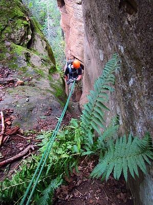
Canyons are inherently risky. Flash floods occur without notice on sunny days. Technical skills & surrounding topography knowledge required yet does not eliminate risk.
Canyoneering
Consensus
View 1
Grade3
WaterA
Risk
TimeII
Statistics
tap row or icons for details
Distance One Way 1.25 miles
Trailhead Elevation 7,012 feet
Elevation Gain -1,200 feet
Kokopelli Seeds 3.25
 Interest Off-Trail Hiking & Seasonal Creek
unreported if dogs are allowed
editedit > ops > dogs to adjust
feature photo
Photos Viewed All MineFollowing
25  2016-03-26 VolcanoCLMBR
26  2013-09-02 GrottoGirl
12  2013-05-04 azflyguy
40  2012-06-03 Vaporman
Author
author avatar Guides 16,843
Routes 17,472
Photos 24
Trips 1 map ( 6 miles )
Age 28 Male Gender
Location HAZ, TrailDEX
Historical Weather
Trailhead Forecast
Radar Map
Expand Map
Preferred May, Jun, Aug, Sep
Sun  6:02am - 6:50pm
Official Route
 
0 Alternative
 
Historic Fire Perimeteracres
🔥 2014 Slide Fire21.7k


remove free decal offer

  Likely In-Season!
Overview
An adventurous crack fault canyon with 8-10 rappels up to 180ft that's great to do when you're in the area and want to stay primarily dry or avoid the monsoons by doing a canyon without much flash flood potential. From the car park, head north down into the canyon. When you're thru the technical section, you can either head down Sterling Canyon to another vehicle left along 89A or head up Sterling Canyon to loop back along 535A to your vehicle.


2018-07-14 HAZ_Hikebot
  • 2021 Verde Valley Trails
    region related
    2021 Verde Valley Trails
  • 2021 Verde Valley Area
    region related
    2021 Verde Valley Area
  • 2021 Sedona Trails Map
    region related
    2021 Sedona Trails Map


Check out the Official Route and Triplogs.
Leave No Trace and +Add a Triplog after your canyon trip to support this local community.
WARNING! Hiking and outdoor related sports can be dangerous. Be responsible and prepare for the trip. Study the area you are entering and plan accordingly. Dress for the current and unexpected weather changes. Take plenty of water. Never go alone. Make an itinerary with your plan(s), route(s), destination(s) and expected return time. Give your itinerary to trusted family and/or friends.

 Permit $$
no fees or permits reported

if incorrect tell us about it


 Directions
or
 Road
High Clearance possible when dry

To canyon trip
From the Oak Creek overlook, head north on 89A a half mile to turn west of FR535. Take FR535 a few mile to south on 535A towards Harding Point. The canyon is a few miles down this road on the left just after that 'trick tank' on the topo. Park near 35.016 -111.7575.
page created by Vaporman on Feb 10 2013 1:34 pm
 90+° 8am - 6pm kills
helpcorrectionissue

end of page marker