 Route Editor

| Guide | ♦ | 12 Triplogs | 0 Topics |
details | drive | permit | forecast | 🔥 route |
stats |
photos | triplogs | topics | location |
| 169 | 12 | 0 |
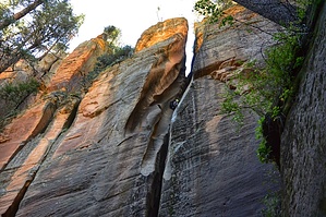
Canyons are inherently risky. Flash floods occur without notice on sunny days. Technical skills & surrounding topography knowledge required yet does not eliminate risk.
 Park somewhere near Buckhead Point and drop into the canyon at 35.0011 -111.7889. Expect to encounter about 10 rappels up to 180ft with some deep waders to brief swimmers. Once out of the narrows, follow the flowing creek down the main canyon towards the West Fork and take that downstream to the parking lot along 89A. Either spot a lower vehicle at Call of the Canyon or follow 89A south to the AB young trail and take that back up to Woody Mt road and walk the road a few miles back to Buckhead Point Park somewhere near Buckhead Point and drop into the canyon at 35.0011 -111.7889. Expect to encounter about 10 rappels up to 180ft with some deep waders to brief swimmers. Once out of the narrows, follow the flowing creek down the main canyon towards the West Fork and take that downstream to the parking lot along 89A. Either spot a lower vehicle at Call of the Canyon or follow 89A south to the AB young trail and take that back up to Woody Mt road and walk the road a few miles back to Buckhead Point
Check out the Official Route and Triplogs. Leave No Trace and +Add a Triplog after your canyon trip to support this local community. | |||||||||||||||||||||||||||||||||||||||||||||||||||||||||||||||||||||||||||||||||||||||||||||


