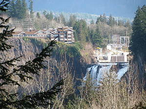
Snoqualmie Falls is one of the must-see attractions in the Greater Seattle area. Most people go Salish Lodge, which sits at the top of the falls for their visit. There is a nice little trail along the rim which offers great views of the falls. However, since it's on the same side as the lodge, those looking for that postcard view of the lodge and falls are left disappointed. The Preston-Snoqualmie Trail offers you the chance to see both the falls and lodge from the opposite side of the river.
"Trail" is a little of a stretch. It's a paved path that I'd call a greenbelt rather than a "trail". The trail actually runs all the way from the small town of Preston to the viewpoint but most people take the last half of the trail. The directions below guide you to the viewpoint trailhead which leaves you with a short 3.6 mile roundtrip walk to the viewpoint. The trail is paved the entire way and is open to bikes as well. While the viewpoint does an offer views of both the lodge and falls, it's partially blocked by trees. And don't forget the zoom for your camera.
The path offers only a slight elevation gain and won't give hardened veterans a real hike workout, but it makes for a nice change of pace if you're in the area. With the easy access and close proximity to Seattle, it's an option for a quick detour on your way home from one of your other hikes in the I-90 corridor.
WARNING! Hiking and outdoor related sports can be dangerous. Be responsible and prepare for the trip. Study the area you are entering and plan accordingly. Dress for the current and unexpected weather changes. Take plenty of water. Never go alone. Make an itinerary with your plan(s), route(s), destination(s) and expected return time. Give your itinerary to trusted family and/or friends.
Permit $$
None
Directions
Road
Paved - Car Okay
To hike From Seattle, take I-90 east to exit 22. Turn left and cross I-90 and then turn right onto Preston Fall City Road SE. Follow this road for almost 4 miles to Lake Alice Road SE (SE 47th St) and turn right. You'll find the trailhead signed on the right after about 1 mile.
 Route Editor