Route Editor

| Guide | ♦ | 10 Triplogs | 1 Topic |
details | drive | permit | forecast | route |
stats |
photos | triplogs | topic | location |
| 152 | 10 | 1 |
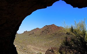
Regal Raptor Roost by outdoor_lover  Overview OverviewOn the eastern edge of the Harquahala Mountain Range, lies a small group of isolated mountains with the largest, Eagle Eye Peak, being named for the large "Eagle Eye" or Arch near the top. This area offers endless off-trail exploring opportunities through a valley of mountains adorned with caves, alcoves, and many rock formations, including arches. There is strong evidence that many raptors call this area home as well. This area has many options from a short Hike, even just a stroll, to all-out bushwacking and scrambling to reach those prime areas near the main Arches and the Peak. Warning Access to many of the caves and alcoves in this area should only be attempted by persons with technical climbing equipment. Please use common sense and don't attempt to gain access to some of these areas unless you have the correct skills necessary to do so.
Harquahala comes from "Aha qua hala", a Native American term meaning "Water there is high up". The small group of mountains to the northeast, isolated from the rest of the Harquahala Range and Wilderness, was deemed Eagle Eye Mountain and Eagle Eye Peak. The town of Aguila which lies just to the north of these mountains was named for this peak, with "Aguila" being Spanish for "Eagle". The area was originally inhabited by a Yuman Tribe of Mariposa Indians dating back as far as 1775 before a Reservation was established along the Gila River in 1858. The area became a small Railroad settlement before the fertile valley became an agricultural giant. The Town of Aguila established in 1909, boasts the world's largest and finest cantaloupes. Hike This hike can be done in many different ways and directions, with many or few destinations. This description will be for a clockwise loop, taking in the three main attractions although side trips can easily be accomplished within this Loop as well. The Hike begins from the small lot in front of the Eagle Eye Cemetery traveling clockwise. Follow the dirt road past the apparent "dumping" site along the eastern edge of the cemetery and over a small pass, entering a valley below. If you just follow the road, eventually you will exit the valley and end up on paved Eagle Eye Road, west of the entire area and you can walk the paved road north, back to your car. Eagle Eye Arch and Peak will be to the east as you enter the valley. As you top out at the pass, you will notice a campsite to your left with a fire ring. Walk through this site and start up the open area of the slope. This area will have a lot of loose lava rock. As you start to get up the slope, you will begin to notice that there is an actual Trail, which will be become more evident the further up you go. This trail will take you through a smaller arch, and also all the way up to the Eagle Eye Arch. There will be very little scrambling on this portion, but it will be steep. Your biggest enemy will be all of the scree. After visiting the Arch, you can scramble to the south and get on the ridgeline that will take you over to Eagle Eye Peak. The trail will take you partway to an area where you can do a climb up. Traverse the base of the cliffs and go around a small rock outcrop and then it's just a short, exposed climb to get to the top. However, when you reach the top, you will not be at the true "peak". You will have passed it and you need to descend into a saddle and then back up. From the peak, you can also follow the ridgeline north and stand on top of the arch. From there, you can pick your poison as far as what route you want to take down, but following the ridgeline further to the south and down is recommended. You will pass a very large alcove on the way down, you may not see it at first, but if you look for it, you'll find it, it's pretty prominent looking back at it. After you are back down in the valley, keep your eye out for the Crested Saguaro in the area between the mountain and the dirt road. Head south to the small mountain at the end of the valley and you will see another, smaller Arch. This can be accessed from either the north or south side. If you want to maintain a true Loop, ascend via the south and descend on the north side. Either way, albeit a little steep in places, it will also require very little scrambling. If hiking around to the south side and up, keep an eye out for Bees, as there appears to be a hive in a crevice at the base of the cliffs, just east of the Arch. On the north side, you will have to ascend at an angle going west and then switchback to the east at the cliff base, to get up. Once you descend from this mountain, proceed north in the valley past the "beginning" of the ridgeline of Eagle Eye Mountain to the west. This is just a rocky outcrop somewhat "disconnected" from the true ridgeline. Start angling your way up the gradual slope and watch for a small, very undefined drainage area going up. This is going to be the easiest way to ascend to the ridgeline and if you can follow it, you will naturally switchback up past the areas that will not allow access. Route finding is a must here, there are very few areas where you will not "cliff out". There will be just a touch of scrambling before you top out on the ridgeline. The ridgeline itself is very rocky with both large and small rocks being somewhat of a bother but follow the ridge north. There will be some scrambling involved before you get to the end. Just before you top out at the end, which is the high point of Eagle Eye Mountain, you will encounter one slightly exposed scramble. At this point, facing this small slope, if you look to your right, you will see a large cave opening in the cliff. Just a landmark to remember. The cave is enticing, but even if you don't mind the exposure enough to get to the entrance, you will not get much farther in without technical equipment. After visiting the high point, you can opt to go back the way you came, or if you're really into scrambling, you can scramble down, starting southeast of the cave and heading northeast. You will eventually turn a corner and see a saddle below you that you can descend to. Or you can opt to follow the cliff face, west, and you will encounter a large alcove with a smaller one next to it. This is also a small bird graveyard as you will find numerous tiny bones discarded by hungry raptors. From here you can descend and go east to the saddle. From the saddle, you have two options. You can turn east, descend back down into the valley and out the way you came via the dirt road, or you can turn west and descend between Eagle Eye Mountain and the mountain to the north of it, following that mountain around to the north side and back to the cemetery. If you aren't tired of the scrambling yet, you can also use the saddle to access the top of the mountain north of Eagle Eye Mountain, as well as explore its slopes. Throughout this entire route, it will become even more evident as to why this area was named after a raptor. Along with the "Eagle Eye", it is strongly apparent that many raptors choose to use this area. Enjoy and be safe! Water Sources None Camping Primitive, dispersed camping and backpacking are allowed. Check out the Official Route and Triplogs. Leave No Trace and +Add a Triplog after your hike to support this local community. | ||||||||||||||||||||||||||||||||||||||||||||||||||||||||||||||||||||||||||||||||||||||||||||||||||||||||||||||||||||||||||||||||||||||||||||||||||||||||||||||||||||||||||||||||||||||