Route Editor

| Guide | ♦ | 11 Triplogs | 0 Topics |
details | drive | no permit | forecast | 🔥 route |
stats |
photos | triplogs | topics | location |
| 172 | 11 | 0 |
Canyons are inherently risky. Flash floods occur without notice on sunny days. Technical skills & surrounding topography knowledge required yet does not eliminate risk.
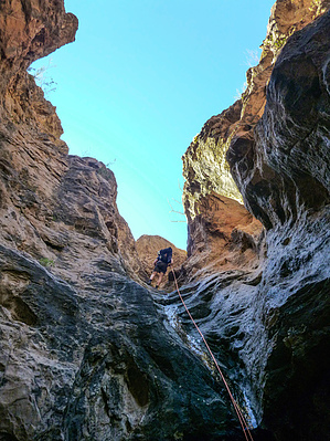
A short but fun canyon by azmike  Overview OverviewA class 3BII technical canyon loop hike in the Superstition Wilderness near Tortilla Flat with 3 rappels, the longest being 70 feet down a chute into a very cool alcove. Warning Headdress is a technical canyon requiring rappelling, stemming, and down climbing skills. Required gear includes a climbing helmet, harness, carabiners, descender, ropes, webbing, rap rings, gloves, canyoneering shoes with good traction, and a wet suit in the winter if water levels are high. This canyon can be done with a 100-foot rope and a 100-foot pull cord (one 200-foot rope would work, as well), 30 feet of webbing, and 3 rap rings.
After a rainstorm, Headdress can quickly become a class 3CII canyon with the final rappel done over a 70-foot waterfall. Flash flooding is a possibility following the rains so canyoneers must monitor the weather and exercise caution before dropping into this canyon. Although this canyon is short, there is one downclimb immediately following the final rappel that may require packs to be passed down. Those not comfortable with this short down climb may want to rig a hand-line. This canyon can also be slippery, especially after a rain so high-traction canyoneering shoes are recommended. The Approach From the overflow parking lot on the east side of the town of Tortilla Flat, hike west up the road past Tortilla Flat, 0.45 miles. The approach starts on the south side of the road near a chain link fence structure just before the road bends sharply to the right. A small white forest service sign about 10-15 feet from the road on the south side marks the start of the hike at (33.52595, -111.39581). Head southeast up a faint use trail to the top of the first hill. Turn right and hike a ridge southwest about an eighth of a mile before dropping down and heading due south for about a third of a mile. This stretch will have you dropping into a small drainage and climbing back up. Once at the top of the next ridge, you will circle to the right of a very large rock formation that stands above Headdress Canyon to the east. Once you circle to the west of this rock formation, you will see a large valley or drainage below which becomes Headdress Canyon. Drop into the canyon at (33.51964, -111.39636) and hike down canyon to the first rappel at (33.51979, -111.39437). First Rappel The first rappel is 36 ft. from a chockstone on RDC. This drop is into a pool of water and requires about a 10-15 ft swim to get across. Second Rappel The second rappel is an optional 15 ft. rappel from a pinch point on a large boulder. This rappel can be bypassed by down-climbing LDC. Third Rappel The third and final rappel is 70 ft. down a chute into an alcove. In low water level conditions, this rappel starts under a large boulder in the center of the canyon, which requires down climbing a few feet through a rabbit's hole under the large boulder. There is enough room for a few people under the boulder. You'll need to pass your packs down to get through the opening. It is a very easy downclimb to get underneath the boulder. Once underneath the boulder, you will look up and see the anchor on a pinch-point to the right. The rappel starts down canyon from underneath the boulder. In higher water level conditions, you may not be able to rappel from underneath the boulder. In this case, you will swing the anchor topside and rappel over the top. This is a waterfall rappel in high water level conditions. The Exit Once the third rappel has been completed, you can gear-down and grab a bite to eat while enjoying the well-shaded alcove. Immediately following the final rappel there is a down climb on RDC past a large boulder. This is a tricky down climb that most will want to pass down packs. I found it easiest to slide down with my back down-canyon, catching a foothold and climbing along the canyon wall several feet before down climbing to the floor of the canyon. Some may want to rig a hand-line if they are uncomfortable with this 10-12 ft down climb. From here the canyon opens up and it is a 15-20 minute hike down the creek bed to Apache Trail Rd. In season, you will most likely find pools of water down canyon that you may be able to hike around. Once you reach the road, turn right and it is a 0.2-mile hike back to the Tortilla Flat overflow parking lot and your car. Water Sources In season, there are plenty of pools of water in this canyon. Check out the Official Route and Triplogs. Leave No Trace and +Add a Triplog after your canyon trip to support this local community. | |||||||||||||||||||||||||||||||||||||||||||||||||||||||||||||||||||||||||||||||||||||||||||||||||||||||||||||||||||