Eureka Peak is more than 50 miles from the 1849 gold rush area of Sutters Mill, California but played an important role in the overall gold rush days. The stories of its discovery vary but quite by accident some men found deposits of placer gold in nearby streams. Pushed out of the area by winter, these men spent the winter dreaming and telling stories of their find. The following spring of 1851 brought them back only to find a rich ledge of gold on top of Eureka Peak. Others followed and in a short time the claims developed into four major mines. The Eureka, Mammoth, Washington and the Rough and Ready mines operated until 1897 producing over 20 million dollars in gold. A trickle of activity lasted well into the 1940 s. Today the entire mountain and surrounding community of Johnsville, Ca, occupied by 100 residents is totally within the Plumas-Eureka California State Park. It is a work in progress as many residents are restoring the buildings.
As you approach the area Eureka Peak stands out with its dramatic rock outcropping on top. There are actually two peaks, a north and south peak separated by about a quarter of a mile. The one highly visible on your arrival is the north peak, the shorter peak, also known as false peak. Our hike will have us bagging both peaks.
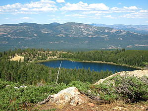
The hike begins in a paved parking lot of a ski lift. At the southwest corner of the lot a gated dirt road starts up the mountain. At times this gate is open and having a 4 X 4 would get you to an alternate trailhead 1.3 miles up the mountain. The first 1.3 miles is up this dirt road which is rough, loose, and fairly steep. There is tree cover providing shade. The road comes out to Eureka Lake, a manmade reservoir. There is fishing, swimming, and kayaking-tubing allowed here. This being the alternate trailhead, the trail starts off across the earthen dam towards the west. It is a climb right from the start as the rocky trail heads into the forest. At 1 miles past the lake an unmarked Y intersection gives you an option. Your loop starts from here and can be accomplished in either direction. To the left is the quicker way to the top but much steeper. To the right is the longer way to the top but a more gradual climb. Either way is a challenge, I will describe a counterclockwise route. Taking off to the right you are surrounded by pine trees with large amounts of moss on them which is common at this altitude in the Tahoe Sierras. Deer Creek is on your right and is generally dry by late summer. As you press on every time you think you are topping off guess what, another false summit. On you go and as you catch sight of the north peak to your left you realize you are higher than it is and onward and upward you go. With no end in sight the trail makes a final switchback and voila, you arrive at a large flat meadow on top of the mountain. The trail comes out to an old jeep road. Take a left on the jeep road and enjoy the flat trail for a quarter of a mile. The trail gets rocky and rough at this point as you enter the southern peak area dominated by rock outcroppings. Enjoy the spectacular views of the surrounding Sierra. You can easily spot the shed sized peak just to your left and you would be derelict not to bag it. I did not find a register. Beneath you are more than 65 miles of mining tunnels. From here you can see false peak to the north and it is considerably lower. The trail takes a gentle descent straight towards false peak. It is rare to find such an easy hike between two peaks. Explore around and perhaps you will find names of miners etched into the rock. From false peak enjoy a beautiful view of Eureka Lake. The trail now starts its steep decent directly west of false peak. It serpentines thru the mossy treed forest to complete the loop. Along the way there are a few streams of water even in late summer from local springs. When you rejoin the original trail return the way you came, enjoying the views of Eureka Lake. Your treasure lies just ahead, just follow the sounds of fun and laughter. I hope you brought your swim trunks. The cool, clear water will make your day.
Gate Policy: If a gate is closed upon arrival, leave it closed after you go through. If it is open, leave it open. Leaving a closed gate open may put cattle in danger. Closing an open gate may cut them off from water. Please be respectful, leave gates as found. The exception is signage on the gate directing you otherwise.
WARNING! Hiking and outdoor related sports can be dangerous. Be responsible and prepare for the trip. Study the area you are entering and plan accordingly. Dress for the current and unexpected weather changes. Take plenty of water. Never go alone. Make an itinerary with your plan(s), route(s), destination(s) and expected return time. Give your itinerary to trusted family and/or friends.
Permit $$
None
Directions
Road
Paved - Car Okay
To hike The park is five miles west of Blairsden on County Road A-14. Off Highway 89 1 mi south of Blairsden and one mile north of Graeagle, California. Continue thru Johnsville to the roads end parking lot for the trailhead.
 Route Editor