Route Editor

| Guide | ♦ | 2 Triplogs | 0 Topics |
details | drive | permit | forecast | route |
stats |
photos | triplogs | topics | location |
| 38 | 2 | 0 |
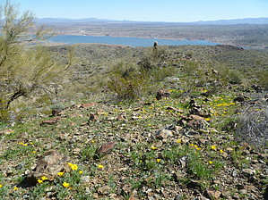
Where's Waldo's adit? by kingsnake  Before I hiked this loop, I figured I would simply attach it to the Alamo Lake Campground description, as I had for BM H+B 1655, a few weeks ago. But after actually doing the hike, I think it deserves its own description. Parts of it are very similar to Ford Canyon, in the White Mountains, so that is what I based the difficulty and route-finding ratings on. Before I hiked this loop, I figured I would simply attach it to the Alamo Lake Campground description, as I had for BM H+B 1655, a few weeks ago. But after actually doing the hike, I think it deserves its own description. Parts of it are very similar to Ford Canyon, in the White Mountains, so that is what I based the difficulty and route-finding ratings on.Turn right out of the Bill Williams overlook, descending towards the dam. There are two markers on the small hill south of the dam, and the best way to find the S-Axis is by going up the old gravel road just before the dam. Never did find BM 1278. After crossing the dam, BM 1276 will be in the rocks to your left. It, as with all but the Williams summit BM, is marked with a white sign on a metal stake. They're not hard to find. Sometimes, you can even see the next BM from the BM you are already at.
From BM 1351, continue north to BM 1279. From this point forward, you will be doing a combination of old jeep trail, goat trail, washes, and cross country. There's a lot of 50 feet here, 50 feet there, type climbs as you move perpendicular to the washes feeding Alamo Lake. After BM 1306 turn northeast towards the adit. It's on the topo, but I could not find it on the ground. Continue northeast hitting the BMs in sequence. BM 1226 is next to a rock with a hole in it, that's big enough for a self-portrait but way too small to be dignified as an arch. The wash between BM 1226 and BM 1188 is steep, deep, and loose, but it's not hard to find a way up. After BM 1202, you will cross a wash full of dead trees, arriving at Alamo Rd. The dirt version, which is on the north shore of Alamo Lake. BM 1198's sign has been knocked off, but it is not hard to find and is in a shady area that would make a good almost-halfway resting spot. You are about 4.5 miles and two hours into the hike. From BM 1198, continue up Alamo Rd for a few hundred feet, before turning west into a wash that I refer to as Boulder Canyon. It starts as an easy ATV run but soon tightens up. About a mile and half of the canyon is bouldering resembling Ford Canyon. Some of the boulders are room-sized. This is one of two highlights of the hike. Beware of bees near any pools that you spot. A couple hundred yards after Boulder Canyon begins opening up, turn south up the north ridgeline of Williams BM. It is steep, loose in spots, and you will have to negotiate a few narrow ledges. Exposure is mostly not a problem, though beware the final few hundred yards are a sheer several hundred-foot drop to the west. The second highlight of the hike is Williams BM. Someone arranged it as a very comfortable rocky recliner, complete with an armrest and footstool. Unfortunately, no remote or beer. Great views all around. Many wildflowers. Summit log is a bit old and brittle, so be careful when signing it. Descending the summit, follow the east ridgeline for about a hundred yards before turning south along a somewhat steep and loose spur. Eventually, you will descend into a branch wash, which will soon deposit you in the main wash, which is wide and sandy. From there, it is a freeway back to BM 1306, which closes the loop. From there, simply backtrack to the dam and trailhead. Check out the Official Route and Triplogs. Leave No Trace and +Add a Triplog after your hike to support this local community. | ||||||||||||||||||||||||||||||||||||||||||||||||||||||||||||||||||||||||||||||||||||||||||||