Route Editor

| Guide | ♦ | 1 Triplog | 0 Topics |
details | drive | no permit | forecast | map |
stats |
photos | triplog | topics | location |
| 15 | 1 | 0 |
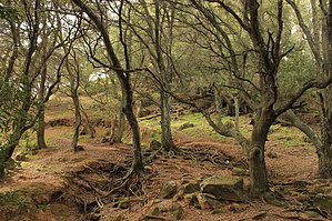
Cowtown by JimmyLyding  The main trailhead is located across the parking lot from the park residence (allegedly occupied). The Coyote Trail heads downhill to the north to a stock pond. Continue on the Coyote as it winds its way steeply downhill through a riparian forest along the headwaters of Marsh Creek for about a mile. The Coyote Trail goes another 1/3 mile or so through a large meadow. The steep slopes on the right are covered in a dense forest of evergreen oak, and the open meadow may have cattle.
The route is out in the open now, and I suspect this portion would be unpleasant in the summer. The trail winds its way around the southern tip of Bob Walker Ridge before crossing over at a small saddle to head south along the ridge's eastern side. It's easy to walk along the crest of the ridge without fear of destroying any native soil or vegetation because the cows have already done exactly that. The Blue Oak Trail branches off to the left/east about 2/3 mile into the Volvon Trail, and it travels into a small valley with a stock tank before rejoining it via the Hummingbird Trail 3/4 mile later. Continue on Blue Oak as the route goes through a surprisingly dense oak woodland, and repeatedly goes up and down for the last 1.25 mile back to the parking lot. Check out the Triplog. Leave No Trace and +Add a Triplog after your hike to support this local community. | ||||||||||||||||||||||||||||||||||||||||||||||||||||||||||||||||||||||||||||||||||||||||||