Route Editor

| Guide | ♦ | 2 Triplogs | 0 Topics |
details | drive | no permit | forecast | 🔥 route |
stats |
photos | triplogs | topics | location |
| 73 | 2 | 0 |
Canyons are inherently risky. Flash floods occur without notice on sunny days. Technical skills & surrounding topography knowledge required yet does not eliminate risk.
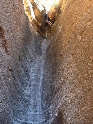
The northern fork into Sierra by azmike  Overview OverviewA class 3AIII technical canyon lasso loop hike in the Superstition Wilderness with an exit onto Fish Creek. This route bypasses the traditional southern fork and the first 5 rappels into Sierra Canyon and drops you into the canyon using the northern fork starting with a 95 ft. rappel down a pretty cool chute before merging with the southern fork of Sierra. Warning Sierra Canyon is a technical canyon requiring rappelling and down climbing skills. Required gear includes a climbing helmet, harness, carabiners, descender, ropes, webbing, rap rings, gloves, and canyoneering shoes with good traction. This canyon can be done with a 100-foot rope and a 100-foot pull cord (one 200-foot rope would work, as well), 60 feet of webbing, and 4 rap rings. Flash flooding is a possibility following the rains so canyoneers must monitor the weather and exercise caution before dropping into this canyon.
From the trailhead parking lot on the north side of Apache Trail Road, follow Fish Creek downstream (north) for 0.5 miles until you come to the first major drainage into Fish Creek on the right side. Start climbing up this drainage to the northwest making sure to stay on the left side of the drainage where there are some signs of a use trail up to Horse Mesa Flats. Stay out of the middle of the drainage if you want to avoid a lot of bushwhacking. Continue to climb until you reach the top and Horse Mesa Flats. Once on top, you will continue heading northeast for 0.25 miles before heading northwest. The northern fork of Sierra Canyon, which runs east-west is halfway between Tango Canyon to the north and the traditional entrance of Sierra Canyon (south fork) to the south. The approach to the northern fork of Sierra follows a similar approach as Tango Canyon but drops into the northern fork of Sierra about 0.25 miles south of the entrance to Tango Canyon. The hike down the canyon is fairly easy with some down climbing before you reach the first rappel at (33.55058 -111.31552). The Canyon The north fork entrance into Sierra Canyon cuts off the first 5 rappels of the traditional southern fork into Sierra. These first 5 rappels are pretty short rappels with some being nuisance rappels. The northern fork adds 2 new rappels of 95 ft. and 45 ft. After the second rappel in the northern fork, the canyon opens up at the confluence of the southern fork and the northern fork. The remainder of the canyon follows the popular description of Sierra Canyon with only two rappels remaining before the exit onto Fish Creek. First Rappel The first rappel is 95 ft. from a pinch point on a stacked boulder back 12-15 ft. from the edge of the drop. The anchor is hidden and doesn't come into view until you downclimb to the rap station. A chockstone blocks the start of the rappel, which makes for an awkward start. It's best to stand on the chockstone before leaning against the canyon wall and rappelling slowly over the chockstone. From there it is a cool rappel down a chute. IMO, it's the best rappel in the canyon. A dual-line 200 ft rope is fine. Second Rappel The second rappel is viewable from the bottom of the first rappel and is 45 ft. from a large BFR several feet back from the edge of the drop. You must be careful not to rappel into the tree below, so stay towards RDC if you can to avoid a tree-top landing. At this point, the canyon opens up and represents the confluence of the north and south fork of Sierra Canyon. Third Rappel The third rappel is 85 ft. from a large BFR on LDC. This anchor requires a large amount of webbing to wrap around the BFR. Rappel down about 65 ft. to a point where you will walk through a narrow slot about 12 ft. to the edge of an unavoidable pool of water. You can get off the rope here or continue across the pool. It is possible to jump across this pool without getting wet. It is only a few feet deep in the middle. Fourth Rappel The fourth rappel is 45 ft. from a boulder atop a stack of boulders. You will need to clip in and downclimb a couple of feet before getting on the rope. The Exit Once the fourth rappel is complete, you can gear down and grab a bite to eat in the shade or hike a few minutes to Fish Creek where there is shade provided by the trees along the creek. Turn left onto Fish Creek and start hiking upstream for 1.9 miles to the trailhead and your car. Depending on the time of year and the weather, there may be water in the creek. After a rain, expect there to be a lot of water in the creek since it is a major drainage into the Salt River. Water Sources In the spring months, expect that Fish Creek will have water. In the canyon, there may be potholes of water depending on recent rains but bring your filter. Check out the Official Route and Triplogs. Leave No Trace and +Add a Triplog after your canyon trip to support this local community. | ||||||||||||||||||||||||||||||||||||||||||||||||||||||||||||||||||||||||||||||||||||||||||||||||||||||||||||