Route Editor

| Guide | ♦ | 3 Triplogs | 0 Topics |
details | drive | permit | forecast | 🔥 route |
stats |
photos | triplogs | topics | location |
| 54 | 3 | 0 |
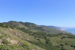
Sky to Sea by JimmyLyding  Take the Sky Trail as it climbs about 500' over this hike's first 3/4 mile to its junction with the Fire Lane Trail on the right followed by the Horse Trail on the left about 50 yards further. The Sky Trail meanders near 1,000' ASL for another 1.75 miles or so before going right on the Woodward Valley Trail. The vegetation from the trailhead to this point has been primarily Douglas fir mixed with California bay laurel, coast live oak, Madrone and Bishop pine with patches of coastal scrub. There are numerous small segments where one side of the trail is shady forest while the other is 6-feet-high scrub. Sky Camp (backpacking only) is 1.25 miles from the trailhead, and there's a vault toilet and a developed spring.
Forget about hitting the beach (Sculptured Beach to be exact) that makes momentary appearances through clefts in the cliff except at the Coast Campground or a mile further ahead where a short spur trail leads down to Santa Maria Beach. Return back to the Coast Trail and head a mile as the trail heads up a wide canyon. The bottom of this drainage is a good sized swamp that ends as the Coast Trail does at Laguna Ranch. Go right at the road where the Coast Trail ends (there's a small roadside parking area here), and go past the youth hostel until the road ends at the Laguna Trailhead. You've gone almost 9 miles to this point, and the proverbial dogs might be barking, but you have another 1.5 mile and about 650' of climbing up the Laguna Trail until it ends at the Bayview Trail. There are dense stands of Bishop pine here, and many of them survived the large 1995 Vision Fire. Go right at Bayview as it parallels Limantour Road for a half mile until it ends at the Sky trailhead. Check out the Official Route and Triplogs. Leave No Trace and +Add a Triplog after your hike to support this local community. | ||||||||||||||||||||||||||||||||||||||||||||||||||||||||||||||||||||||||||||||||||||||||||||||||||||||