Route Editor

| Guide | ♦ | 4 Triplogs | 0 Topics |
details | drive | no permit | forecast | route |
stats |
photos | triplogs | topics | location |
| 43 | 4 | 0 |
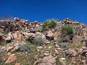
  Overview OverviewNorth of Globe, AZ, near the boundary with the Salt River Canyon Wilderness and 0.2mi off FR645, resides the TH Start for this quick and easy access "off-trail" hike to summit Black Mountain 4515 feet. This random summit has ancient Indian Ruins with numerous rooms of collapsed walls, some pottery shards, and scenic near and distant 360-degree views into the Salt River Canyon Wilderness and beyond. Check out the Official Route and Triplogs. Leave No Trace and +Add a Triplog after your hike to support this local community. | |||||||||||||||||||||||||||||||||||||||||||||||||||||||||||||||||||||||||||||||||||||