username
X
password
register
for free!
help


Blackjack Mtns to Upper Hess Canyon, AZ

Guide 5 Triplogs  0 Topics
  3.7 of 5  
Fav
Wish
0
details
drive
no permit
forecast
route  
stats
photos
triplogs
topics
location
24 5 0
Statistics
tap row or icons for details
Difficulty 4 of 5
Route Finding 2 of 5
Distance One Way 2.9 miles
Trailhead Elevation 4,171 feet
Avg Time One Way 2 hours
 Interest Off-Trail Hiking, Historic & Seasonal Creek
unreported if dogs are allowed
editedit > ops > dogs to adjust
feature photo
Photos Viewed All MineFollowing
Will recalculate on button tap!
49  2022-01-30
Blackjack Jackson
DixieFlyer
42  2013-04-16
Blackjack Mtns Ridgeline Loop
Grasshopper
17  2013-03-23 rwstorm
7  2013-03-23 Grasshopper
88  2013-03-22
Camp Grasshopper - S/R Cyn Wilderness (FR346)
Randal_Schulhaus
Author
author avatar Guides 16,843
Routes 17,472
Photos 24
Trips 1 map ( 6 miles )
Age 28 Male Gender
Location HAZ, TrailDEX
Historical Weather
Trailhead Forecast
Radar Map
Expand Map
Preferred Mar, Nov, Apr, Oct
Sun  5:59am - 6:43pm
Official Route
 
2 Alternative


remove free decal offer

  
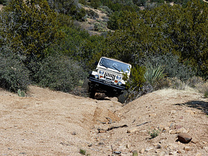
North of Globe, AZ, near the boundary with the Salt River Canyon Wilderness, this serious 5.8 mile "modified vehicle only" 4WD round-trip begins off of FR645 at the unmarked and gated Blackjack Mountains 4WD/Ranching Access Road to end 2.9 driving/hiking miles later at the very remote Upper Hess Canyon drainage. Scenic views of the Blackjack Mtn Range to the west and historic ranching history prevail.


Gate Policy: If a gate is closed upon arrival, leave it closed after you go through. If it is open, leave it open. Leaving a closed gate open may put cattle in danger. Closing an open gate may cut them off from water. Please be respectful, leave gates as found. The exception is signage on the gate directing you otherwise.

2018-07-14 HAZ_Hikebot


    Check out the Official Route and Triplogs.
    Leave No Trace and +Add a Triplog after your 4x4 trip to support this local community.
    WARNING! Hiking and outdoor related sports can be dangerous. Be responsible and prepare for the trip. Study the area you are entering and plan accordingly. Dress for the current and unexpected weather changes. Take plenty of water. Never go alone. Make an itinerary with your plan(s), route(s), destination(s) and expected return time. Give your itinerary to trusted family and/or friends.

     Permit $$
    None


     Directions
    or
     Road
    Strictly 4x4

    To 4x4 trip
    From the Phoenix Area: Just east of Globe, AZ, at the intersection of Hwy60/Hwy70, take Hwy 60 north for 16.3 miles to exit left (NW) onto FR303-Haystack Butte Road. Take FR303 to FR645 and turn left (west) onto FR645. Take this FR645 Loop Road for several miles to the FR645/Blackjack Mtns Area 4WD Road EXIT at waypoint coordinate N33 39.277 W110 41.018; Turn left (north) to begin this 2.9-mile one way "serious, modified 4WD vehicle only" drive to end at Upper Hess Canyon Drainage (please see posted and attached 4WD GPS Route with key WPs for download and following).
    page created by Grasshopper on Mar 27 2013 1:58 pm
     90+° 8am - 6pm kills
    helpcorrectionissue

    end of page marker