username
X
password
register
for free!
help
 This is likely a great time to hike this trail!  Check out "Preferred" months below, keep in mind this is an estimate. 
  🔥

Mt Esther Trail, CO

Guide 59 Triplogs  0 Topics
  4 of 5  
Fav
Wish
0
CO > South
details
drive
no permit
forecast
🔥
route  
stats
photos
triplogs
topics
location
352 59 0
Statistics
tap row or icons for details
Difficulty 4 of 5
Distance Round Trip 3.55 miles
Trailhead Elevation 7,995 feet
Elevation Gain 1,411 feet
Accumulated Gain 1,886 feet
Kokopelli Seeds 12.98
 Interest Historic & Peak
feature photo
Photos Viewed All MineFollowing
9  2024-06-02 sneakySASQUATCH
12  2020-04-27
Linking trails in the hood
sneakySASQUATCH
4  2020-03-24 sneakySASQUATCH
9  2019-10-28 sneakySASQUATCH
14  2019-10-10
What a difference a day makes
sneakySASQUATCH
4  2019-09-26 sneakySASQUATCH
17  2019-07-17
Crystal Creek Reservoir via Mt. Esther trai
sneakySASQUATCH
3  2018-11-04 sneakySASQUATCH
Page 1,  2,  3,  4,  5
Author
author avatar Guides 16,843
Routes 17,472
Photos 24
Trips 1 map ( 6 miles )
Age 28 Male Gender
Location HAZ, TrailDEX
Associated Areas
list map done
South Region
Historical Weather
Trailhead Forecast
Radar Map
Expand Map
Preferred Sep, May, Oct, Aug
Sun  5:32am - 6:24pm
Official Route & 1 Rt
 
1 Alternative
 
Historic Fire Perimeteracres
🔥 2012 Waldo Canyon Fire18.2k


remove free decal offer

 Likely In-Season! 
Guide Needed
Publish Full Detail Guide


Use +Add above to share photos and triplogs
Overview
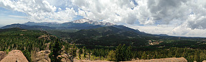
Nice hike in Ute pass in Cascade/Chipita Park which in itself is a destination, but also links up to Ring the Peak trail which is a 57 mile trail around Pikes Peak with numerous other trail links.


    Check out the Official Route and Triplogs.

    Note
    This is a moderately difficult hike.
    Leave No Trace and +Add a Triplog after your hike to support this local community.
    WARNING! Hiking and outdoor related sports can be dangerous. Be responsible and prepare for the trip. Study the area you are entering and plan accordingly. Dress for the current and unexpected weather changes. Take plenty of water. Never go alone. Make an itinerary with your plan(s), route(s), destination(s) and expected return time. Give your itinerary to trusted family and/or friends.

     Permit $$
    None


     Directions
    or
     Road


    To hike
    Colorado Springs to the 24 past Manitou Springs to Ute Pass turn left at the light at Cascade keep right at the Pikes Peak highway sign following Chipita Park rd. 1.5 miles. Turn left on Picabo and turn left on Mtn. rd. Trailhead on the right.
    page created by sneakySASQUATCH on Mar 28 2013 2:04 pm
     90+° 8am - 6pm kills
    helpcorrectionissue

    end of page marker