Route Editor

| Guide | ♦ | 1 Triplog | 0 Topics |
details | drive | no permit | forecast | route |
stats |
photos | triplog | topics | location |
| 19 | 1 | 0 |
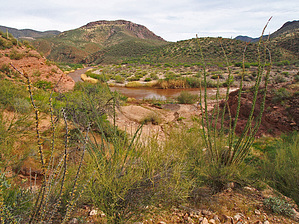
Scenic walk to the Salt River by Oregon_Hiker  Overview OverviewThis is a short off-trail hike to the Salt River at the mouth of Lower Corral Canyon. The hike starts at the end of a 3.9-mile 4WD road starting at Cherry Creek Road and ending at the Salt River Canyon Wilderness boundary. Fantastic views of the Sierra Ancha along the west side of Cherry Creek Canyon can be seen as you drive up to the canyon's eastern rim. The end of the road and the starting point of this hike is on top of a ridge looking down on Upper Corral Canyon to the north and Lower Corral Canyon to the South. This is a great place to car camp with views of the White Ledges on the south side of the Salt River. The hike is listed as off-trail but follows a fading 4WD trail along ridge tops for about 0.7 miles before it completely fades away. Because the road continues past the wilderness boundary, it probably predates the 1984 establishment of this wilderness. Glimpses of the Salt River can be seen as you hike along this ridge. Shortly after the end of the old 4WD road, the route proceeds down the ridge's spine on the west side of a wash to the river. A faint path along the ridge makes this fairly easy for route finding and helps with leading you through openings in some heavy brush as you near the river. The path ends at a sand dune near the river. This area is sometimes used as a campsite for river runners. The river running season is from March 1 to May 15. After reaching the river, you can follow the shore for about 0.2 miles downstream. Beyond that, the canyon walls drop steeply into the river and make passage difficult to impossible except maybe at low river levels. Hiking upstream would require going up on the hillside to get around a cliff.
The 4WD road to the hike starting point intersects Cherry Creek Road 0.8 miles north of the creek crossing. I don't recall seeing any road markings at this intersection, but it is marked as FR1690 a ways up the road. This 4WD road follows the bottom of a dry wash for about 1.2 miles before heading up the south side of the wash to the ridge top. The section of road up the dry wash was in good condition on the day I drove it but could quickly change after the next flash flood. The climb out of the wash was relatively steep and might require 4WD. Somewhere along the route, after passing an intersection, the road changes to FR1790 based on a road marker but don't expect to see these markers at the intersections. The road climbs up to the top of Cherry Creek Canyon's eastern rim after driving 2.6 miles from Cherry Creek Road. At this point, it passes through a gate. This would be a good alternate stopping point for the drive if you want to avoid AZ pinstriping along the route's remainder. It would add about 2.6 miles (roundtrip) to the 3.2-mile hike. Passing through the gate, continue driving to where the road stops on top of a ridge at the Salt River Cny Wilderness boundary overlooking the Lower Corral Canyon drainage. Heavy pin striping was encountered over the last part of the route and sections requiring high ground clearance and 4WD. The stopping point for driving offers plenty of space to turn around and level ground for camping. The hiking portion of this trip continues down the remains of a rugged 4WD road. This road fades away into the brush after about 0.7 miles as it follows the ridgeline heading generally east. Continue to follow this ridge to the east about 0.15 miles until you come to a fence that marks the Fort Apache Indian Reservation boundary. At this point, turn south and descend a reasonably steep but open slope to a ridge sloping downward and extending to the Salt River between two washes. There is a faint trail along the top of this ridge, which leads you through openings in the thick brush encountered as you near the river. At the tip of the ridge, there is a cairn where the trail turns 90 degrees and crosses a wash before reaching a large sand dune on the river's upper bank. Gate Policy: If a gate is closed upon arrival, leave it closed after you go through. If it is open, leave it open. Leaving a closed gate open may put cattle in danger. Closing an open gate may cut them off from water. Please be respectful, leave gates as found. The exception is signage on the gate directing you otherwise. Check out the Official Route and Triplog. Leave No Trace and +Add a Triplog after your hike to support this local community. | |||||||||||||||||||||||||||||||||||||||||||||||||||||||||||||||||||||||||||||||||||||||||||||