 Route Editor

| Guide | ♦ | 19 Triplogs | 1 Topic |
details | drive | permit | forecast | route |
stats |
photos | triplogs | topic | location |
| 157 | 19 | 1 |
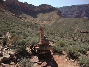
Old Prospectors Trail by John9L  History: This route was used by prospectors to access their claims along the Colorado River. This dates back to the days before the River Trail was constructed. Signs of trail construction are obvious. History: This route was used by prospectors to access their claims along the Colorado River. This dates back to the days before the River Trail was constructed. Signs of trail construction are obvious.You can follow this route in either direction, but this is written describing the ascent from the river.
The route up the break in the Tapeats is steep and loose but relatively easy to follow. Again, the route will lead you up to some established switchbacks with a mixture of scrambling. Near the top look for a switchback that heads to the north. Follow this for a couple of minutes before it turns back to the south for the final stretch which leads to the Miner's Cairn at the top. The Miner’s Cairn is a very large rock pile with a fairly large rock pointing directly up toward the sky. From the Miners Cairn, proceed south and head cross country towards the Tonto Trail. No clear route exists, but an option is to follow the wash that leads back to the Tonto Trail. Once on the Tonto, you can head east a quarter mile to the South Kaibab Trail or west a few miles back to the Bright Angel Trail. You can also take the Skeleton Point Route back to the South Kaibab Trail. It leads to the top of the Redwall switchbacks a little above the halfway point. Check out the Official Route and Triplogs. Note This is a moderately difficult hike. Leave No Trace and +Add a Triplog after your hike to support this local community. One-Way Notice This hike is listed as One-Way. When hiking several trails on a single "hike", log it with a generic name that describes the hike. Then link the trails traveled, check out the example. | ||||||||||||||||||||||||||||||||||||||||||||||||||||||||||||||||||||||||||||||||||||||||||||||||||||||||||||||||||||||||||||||||||||||||||||||||||||||||||||||||||||||||||||||||||||||||||||


