 Route Editor

| Guide | ♦ | 3 Triplogs | 0 Topics |
details | drive | no permit | forecast | map |
stats |
photos | triplogs | topics | location |
| 139 | 3 | 0 |
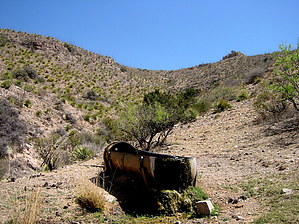
It Is Really Only Half Mile Long! by imike  As you stand at the lower tank you will note the cattle track moving off and up to your right as you stare up the small canyon. That is your trail.
The Lower Pipe Springs is located just above and across from the intersection of the upper trailhead for the Roundup Grounds Trail (t107), and just below and across from the mouth of Purgatory Canyon. The low bench formation on the north side of Alamo Canyon once held a portion of the old mine road, now mostly gone from sight, but the canyon cut above the bench is clear. Walk up onto and up into the cut until you reach the metal water tank, probably overflowing and creating a seeping spring down the hill. The Lower Pipe Springs will likely have cattle loitering about... a common mess in the Sacramento Mountains. Upper Pipe Springs is easily located along the roadway that follows the Aquaduct Ridge Trail. The ABS pipeline flows out and down from the concrete tank overflow. If hiking down from above, simply follow the pipeline down the hill to the south. The intersection with the cattle track diverting off to your left can be faint, but if all of a sudden you find yourself going too steeply down into the canyon... you passed it! Turn around and move back up hill. There are cliffs below you; use the trail. This handy spur trail allows for nice and easy access to the ridge... and gives you a trail connecting route on up to Pyramid Peak and beyond. Check out the Triplogs. Leave No Trace and +Add a Triplog after your hike to support this local community. One-Way Notice This hike is listed as One-Way. When hiking several trails on a single "hike", log it with a generic name that describes the hike. Then link the trails traveled, check out the example. | ||||||||||||||||||||||||||||||||||||||||||||||||||||||||||||||||||||||||||||||||||||||||||


