Route Editor

| Guide | ♦ | 5 Triplogs | 0 Topics |
details | drive | permit | forecast | 🔥 route |
stats |
photos | triplogs | topics | location |
| 44 | 5 | 0 |
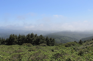
Hike up to a peak then down to the beach by JimmyLyding  From the Muddy Hollow Trailhead go about .2 mile on the Muddy Hollow Road (actually a dirt trail) then go right on the Bayview Trail for about 1/2 mile. This area is a nice open chaparral interspersed with a relatively short riparian forest. Now go left on the Drakes View Trail as the serious climbing gets underway. Drakes View gains about 800 feet over 2 miles as it climbs to the Inverness Ridge Trail through tall coastal chaparral scrub then gloomy Bishop pines.
Go south from the summit on the west side of the government stuff to the Bucklin Trail. There are cool views to the east before the trail plunges into more dark stretches through Bishop pine. It's amazing to think that about 1/3 of these trees in this area were burned only 18 years ago when they form such an overarching presence over so much of this hike. Some spots of chaparral provide nice views to the west of the Glenbrook Creek drainage. I imagine very nice views of Estero de Limantour and the Limantour Spit on a clear day, but my visit featured foggy, overcast weather. 2.3 miles of Bucklin leads to the Muddy Hollow Road, and go left about another mile to the trailhead. There is a lot of poison oak on this trail. There is a lot of brushing against vegetation in general on this hike so strong bug juice and long pants are recommended. It's about 7 miles to this point, but how can you not go to the beach? Go out of the south end of the parking lot on the Muddy Hollow Trail for 0.3 mile to a junction with the Estero Trail then 1.5 miles to Limantour Beach. The Muddy Hollow drainage to the left/west is lush and well-watered. Eventually there are small pools then sloughs as you approach the coast. My initial visit was cloudy, cool and windy, but this is probably a very nice spot most of the time. This is also the end of the Limantour Road so there are likely to be lots of people. Limantour Beach runs about 1.5 miles west to the end of Limantour Spit and turns into Santa Maria Beach to the east. Return the way you came. Check out the Official Route and Triplogs. Leave No Trace and +Add a Triplog after your hike to support this local community. | ||||||||||||||||||||||||||||||||||||||||||||||||||||||||||||||||||||||||||||||||||||||||||||||||||||||