|
Apache Wash
|
7.24 mi
976 ft |
 |
|
Apache Wash Loops
|
6.44 mi
740 ft |
 |
|
Apache Wash
|
6.5 mi
727 ft |
 |
|
Ocotillo Ridgeback Sidewinder Loop
|
4.45 mi
496 ft |
 |
|
Apache Wash
|
7.27 mi
935 ft |
 |
|
Ocotillo - Ridgeback - Sidewinder
|
4.55 mi
561 ft |
 |
|
Apache Wash Loop
|
7.22 mi
920 ft |
 |
|
Apache Wash
|
6.44 mi
820 ft |
 |
|
Apache Wash
|
7.2 mi
933 ft |
 |
|
Apache Wash loops
|
8.66 mi
1,227 ft |
 |
|
Esplanade Owl Checkup and Apache ...
|
8.03 mi
469 ft |
 |
|
And it begins
|
9.98 mi
1,264 ft |
 |
|
Apache Wash
|
7.2 mi
905 ft |
 |
|
Sidewinder - Apache Vista
|
2.75 mi
306 ft |
 |
|
Apache Wash
|
7.15 mi
1,016 ft |
 |
|
Apache Vista - Ridegeback Overlook
|
6.54 mi
849 ft |
 |
|
Ocotillo - Apache - Sidewinder
|
4.11 mi
276 ft |
 |
|
Apache Creek 7.16 Miler :)
|
7.16 mi
887 ft |
 |
|
Apache Wash
|
7.17 mi
889 ft |
 |
|
Sidewinder Ridgeback Wildflower Loop
|
4.72 mi
579 ft |
 |
|
Sidewinder Trail - Sonoran Perser...
|
4 mi
488 ft |
 |
|
Esplanade Owl Check - Apache Wash...
|
7.75 mi
215 ft |
 |
|
Sidewinder via Apache Vista
|
5.36 mi
517 ft |
 |
|
Apache Vista twice - Sidewinder -...
|
7.86 mi
1,067 ft |
 |
|
Ridgeback Loop
|
4.69 mi
594 ft |
 |
|
Apache Wash - Sidewinder - Double...
|
6.75 mi
624 ft |
 |
|
Sidewinder Ridgeback
|
4.68 mi
563 ft |
 |
|
Sidewinder and Apache Vista
|
5.36 mi
507 ft |
 |
|
Apache Wash
|
11.71 mi
1,060 ft |
 |
|
Esplanade Owl Search
|
5.39 mi
321 ft |
 |
|
Esplanade Owl Search and Apache V...
|
7.98 mi
674 ft |
 |
|
Sonoran Preserve North - Southeas...
|
8.74 mi
282 ft |
 |
| Apache Wash Loop - Sonoran Preser...
|
10.64 mi
360 ft |
|
|
|
Ocotillo Sidewinder Ridgeback Apache
|
10.47 mi
1,375 ft |
 |
| Apache Wash Ocotillo Long Loop
|
20.15 mi
1,656 ft |
|
|
| Apache Wash Loop
|
12.94 mi
468 ft |
|
|
| Apache Wash Roundabout
|
6.57 mi
661 ft |
|
|
|
Apache Vista Double and Apache Wa...
|
9.93 mi
785 ft |
 |
|
Phoenix Sonoran Preserve N Highpo...
|
7.88 mi
976 ft |
 |
| Sonoran Preserve Loop
|
7.91 mi
299 ft |
|
|
|
Sonoran Preserve Loop
|
7.88 mi
359 ft |
 |
|
Apache Vista Double
|
5.85 mi
636 ft |
 |
|
Apache Wash Loop
|
9.71 mi
1,341 ft |
 |
|
Esplanade Owl Search
|
5.3 mi
171 ft |
 |
|
Sonoran North via Apache Wash
|
16.04 mi
2,178 ft |
 |
|
Sonoran North via Apache Wash
|
15.94 mi
2,078 ft |
 |
|
Esplanade Trail - Sonoran Preserv...
|
9.87 mi
309 ft |
 |
| Esplanade Trail - Sonoran Preserv...
|
11.63 mi
530 ft |
|
|
| Apache Vista Trail - Sonoran Pres...
|
6.88 mi
1,024 ft |
|
|
| Esplanade-Cliff Walk loop
|
9.31 mi
344 ft |
|
|
| Cliff Walk Trail - Sonoran Preser...
|
11.75 mi
432 ft |
|
|
| Sonoran Preserve North Sampler
|
12.53 mi
1,073 ft |
|
|
| Apache Wash Loops
|
5.7 mi
480 ft |
|
|
| Badger Brawl Trail - Sonoran Pres...
|
8.25 mi
299 ft |
|
|
| Sidewinder Trail - Sonoran Perser...
|
4.94 mi
646 ft |
|
|
| Ridgeback Overlook Trail - Sonora...
|
4.54 mi
580 ft |
|
|
| Sidewinder Trail - Sonoran Perser...
|
4.96 mi
642 ft |
|
|
| Apache Wash Loop - Sonoran Preser...
|
7.11 mi
271 ft |
|
|
| Apache Wash / Badger Brawl / Clif...
|
4.72 mi
171 ft |
|
|
| Apache Wash / Esplanade Trail
|
5.38 mi
166 ft |
|
|
| Esplanade Trail - Sonoran Preserv...
| 2015-02-24 |
AZWanderingBear |
|
3.35 mi
175 ft |
|
|
| Apache Wash Loop
|
2.72 mi
305 ft |
|
|
| Sonoran North Loop
|
14.73 mi
1,795 ft |
|
|
| Sonoran Preserve - North Area
|
7 mi
853 ft |
|
|
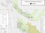
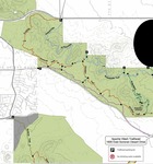
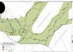
 This is a short connector trail running between the Sidewinder and Ocotillo Trails in the Phoenix Sonoran Preserve Northern Area. It is near the eastern end of the park and facilitates loop hikes in the park. Its northern terminus is at N33 46.568 W112 02.812 (Milepost 1.18 on the Sidewinder Trail). Its southern end is at N33 46.284 W112 02.928. From the north it is a gradual downhill hike curving around the hill to the east. It is useful as part of a longer hike and not as a trail by itself.
 Route Editor


