Route Editor

| Guide | ♦ | 1 Triplog | 0 Topics |
details | drive | permit | forecast | map |
stats |
photos | triplog | topics | location |
| 24 | 1 | 0 |
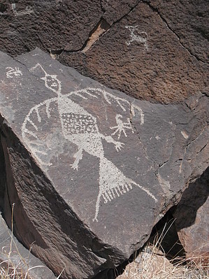
Canoe paddle a kayak? by azbackpackr   This short trail is on the opposite shore of Lyman Lake from all the park facilities. There is only one practical way to get to the trail--by boat. A kayak or canoe will work just fine, but watch out for the gusty winds that come up. The park rangers used to offer a boat and hiking tour to see the petroglyphs, but with the current budget cuts in the park system, this service has been eliminated. No boat rentals are available at the park, so you will need to plan ahead and bring one with you. This short trail is on the opposite shore of Lyman Lake from all the park facilities. There is only one practical way to get to the trail--by boat. A kayak or canoe will work just fine, but watch out for the gusty winds that come up. The park rangers used to offer a boat and hiking tour to see the petroglyphs, but with the current budget cuts in the park system, this service has been eliminated. No boat rentals are available at the park, so you will need to plan ahead and bring one with you.It would be possible to walk around the lake to reach the petroglyph area, but I think it would take all day. It is very rough, rocky ground. In summer it is nearly always very hot.
Launching your kayak from the beach camping area, paddle straight across the lake, looking for a small building located a short distance from the beach, back in the brush. This small building is along the trail and has interpretive signage inside, and a picnic table. Once you have landed on the beach and walked up to the small building, it's easy to see the trail. Follow it, watching closely for petroglyphs on the rocks. Once you get to the end of the trail, you will see a bench and a large boulder with many petroglyphs on it. This is called "Ultimate Rock." Remember, do not touch the petroglyphs, since the oils on your hands can damage them. It is also illegal to do rubbings. Despite the fact they have been there for 800 to 1000 years or more, they are fragile. Check out the Triplog. Leave No Trace and +Add a Triplog after your hike to support this local community. | ||||||||||||||||||||||||||||||||||||||||||||||||||||||||||||||||||||||||||||||||||||||