Route Editor

| Guide | ♦ | 3 Triplogs | 0 Topics |
details | drive | no permit | forecast | route |
stats |
photos | triplogs | topics | location |
| 10 | 3 | 0 |
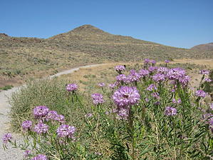
Huff and Puff - Not by AZLOT69  The hike starts from a typical city park with tennis courts, restrooms, green grass, and park benches. A small bridge crosses an agricultural flume which generally has water in it year round. The volcanic rock in front of you is full of colonies of California ground squirrels. The initial climb is a couple of switchbacks with interpretive signs along the way. Soon a Gazebo comes into view high on the hill ahead. There are several benches at various view points. There are two distinct peaks both of which you can make a side trip up to. If you are short on time you could also cut the loop in half by looping only one or the other peaks. There is a cutoff trail. The full loop continues to the south and levels off. Its not unusual to see joggers, mountain bikes, and dog walkers also using the trail. Wildflowers are common throughout the summer even though rainfall is non existent. The trail has only minor changes in elevation from this point as it passes barb wired fencing and rock drift fences from an earlier era. Suddenly the hike is over, oh what the heck do it again in reverse. The view is completely different. Check out the Official Route and Triplogs. Leave No Trace and +Add a Triplog after your hike to support this local community. | |||||||||||||||||||||||||||||||||||||||||||||||||||||||||||||||||||||||||||||||||||||