username
X
password
register
for free!
help
  This is likely a great time to hike this trail!  Check out "Preferred" months below, keep in mind this is an estimate.
  

Glen Aulin Falls, CA

Guide 5 Triplogs  0 Topics
  5 of 5  
Fav
Wish
1
details
drive
permit
forecast
map
stats
photos
triplogs
topics
location
12 5 0
Statistics
tap row or icons for details
Difficulty 2.5 of 5
Route Finding 2 of 5
Distance Round Trip 11 miles
Trailhead Elevation 7,828 feet
Accumulated Gain 600 feet
Avg Time Round Trip 6-8 hours
Kokopelli Seeds 14
 Interest Historic, Perennial Waterfall & Perennial Creek
 Backpack Yes
unreported if dogs are allowed
editedit > ops > dogs to adjust
feature photo
Photos Viewed All MineFollowing
60  2023-08-03
Grand Canyon of the Tuolumne Loop
chumley
39  2023-08-03
Grand Canyon of the Tuolumne Loop
BiFrost
57  2016-07-22
Grand Canyon of the Tuolumne River
John9L
45  2016-07-22
Grand Canyon of the Tuolumne River
chumley
12  2013-06-01 lP14
Author
author avatar Guides 4
Routes 0
Photos 436
Trips 46 map ( 253 miles )
Age 45 Female Gender
Location Tucson, AZ
Associated Areas
list map done
Sierra Nevada Region
Historical Weather
Trailhead Forecast
Expand Map
Preferred Sep, Jun, May, Oct → 8 AM
Seasons   Late Spring to Early Autumn
Sun  5:30am - 6:23pm
0 Route
 
3 Alternative


  Likely In-Season!
The hike takes you from the seasonally crowded Tuolumne Meadows, along the Tuolumne River, to the beautiful and impressive Glen Aulin Falls. Walk a little further to the High Sierra Camp, with the option to continue to some additional falls (California, LeConte, Waterwheel) and views of the grand canyon of Yosemite. The trails are well marked and often quite wide, so route finding only becomes (somewhat but not really) tricky at water crossings.


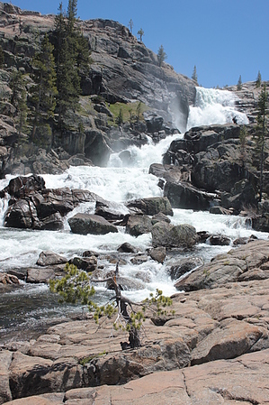
You have the option of starting this hike from several trailheads, but we began at Soda Springs. We hiked early in the season in a low snowpack year, before the high elevation campgrounds were open, so we had options. During busier times, you might have to make do based on where you can find parking.
remove free decal offer
You begin by walking across Tuolumne Meadows and soon join up with the river. From that point, the trail generally keeps you within at least earshot of the river, while meandering through wooded areas, meadows, and granite expanses (which are marked by cairns and reflectors in trees). There were several unbridged water crossings within the first couple miles of the hike, which we were able to manage quite easily, though I imagine at different points in the season and rain/snowfall levels, this will vary.

The trail loses elevation gradually, most of the 600 feet of loss occurs alongside the falls and if you are worried about that, you can turn around before reaching the turnaround point at the camp. However, the trail was never steep in my opinion. I would suggest bringing bug spray as the mosquitoes are mighty and many, and make sure you have sunscreen because walking through meadows and across granite leaves you exposed to the bright California sun.

2013-06-03 lP14
  • Yosemite Park Map
    area related
    Yosemite Park Map
  • Yosemite Campgrounds
    area related
    Yosemite Campgrounds


Check out the Triplogs.
Leave No Trace and +Add a Triplog after your hike to support this local community.
WARNING! Hiking and outdoor related sports can be dangerous. Be responsible and prepare for the trip. Study the area you are entering and plan accordingly. Dress for the current and unexpected weather changes. Take plenty of water. Never go alone. Make an itinerary with your plan(s), route(s), destination(s) and expected return time. Give your itinerary to trusted family and/or friends.

 Permit $$
NPS

Yosemite National Park
Fees & Passes
Half Dome Permit - Currently required 7 days a week. Check the link for the most up-to-date information.

2014 - 300 permits issued daily, 225 for dayhikers.
2013 - 400 permits issued daily, 300 for dayhikers.


 Directions
or
 Road
Paved - Car Okay

To hike
From the East Entrance/Tioga Pass: Enter park on Tioga road and follow it for 8 miles west. Soda Springs Trailhead will be on the right, parking available off the side of the road.

From Yosemite Valley: Take CA-120 west until Crane Flat. Turn right onto Tioga Road and follow for 38 miles to Tuolumne Meadows. Soda Springs Trailhead will be on the left, parking available off the side of the road.

From CA-120 East: Enter the park on CA-120 and head east until Crane Flat. Turn left onto Tioga Road. Follow for 38 miles until you reach Tuolumne Meadows. Soda Springs Trailhead will be on the left, parking available off the side of the road.
page created by lP14 on Jun 02 2013 7:00 am
 90+° 8am - 6pm kills
helpcorrectionissue

end of page marker