Route Editor

| Guide | ♦ | 2 Triplogs | 0 Topics |
details | drive | no permit | forecast | route |
stats |
photos | triplogs | topics | location |
| 21 | 2 | 0 |
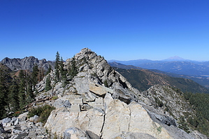
Up up and away by JimmyLyding The parking lot at 4400' has a large circular parking lot with rough-looking roads heading off to the left and right of the well-marked trailhead. Head up the Stoney Ridge Trail as it gradually climbs through chaparral woodland and red dirt that are reminiscent of many parts of the Southwest. The trail climbs 1.3 miles and 600' to the start of the switchbacks. There are a few views here to the south of Monument Peak and the large Stuart Creek drainage. The dreaded switchbacks climb 1,500' over 2.3 miles (not too bad, but definitely not a stroll in the park) on a well-maintained trail to the first junction of the hike.
The trail heads to the north until meeting up with the Granite Peak Trail 1/2 mile ahead before another 1/2 mile and 400' of switchbacks leads to the summit. I understand there are the remains of an old lookout, but I didn't actually visit the summit on my initial hike due to a snowfield before the Granite Peak Trail junction (and being 20 min. past my turnaround time) so take that portion of this description with a grain of salt. Check out the Official Route and Triplogs. Note This is a moderately difficult hike. Leave No Trace and +Add a Triplog after your hike to support this local community. | |||||||||||||||||||||||||||||||||||||||||||||||||||||||||||||||||||||||||||||||||||||||||||||