Route Editor

| Guide | ♦ | 1 Triplog | 0 Topics |
details | drive | no permit | forecast | route |
stats |
photos | triplog | topics | location |
| 32 | 1 | 0 |
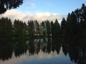
Gateway to the Ardennes by kingsnake While most people are familiar with French (Walloon) and Dutch (Flemish) Belgium, few are aware there is also a German-speaking region. Naturally enough, it is near Germany. St. Vith, a town of less than 10,000 people, is in that region, the Schnee Eifel ("snowy forest") two hours southeast of Brussels, Belgium, and three hours west of Frankfurt, Germany. Other than a really nice pensione, the Hotel Steineweiher, and some historical markers, there is not much to the town itself. The countryside is beautiful though: In my opinion, southern Belgium, and Luxembourg, is the most beautiful part of Europe. History St. Vith is the gateway to the Ardennes, which is most famous for two battles: The German invasion of France, in May, 1940, and the Battle of the Bulge, in winter 1944-45. Since this is where both battles began, it is a good place to begin a chronological tour of the battlefields. If you spend any time driving the twisty country lanes, you will quickly realize what a difficult task it is to shove a large amount of armor through the forests and narrow, steam-filled, canyons.
In addition to World War II, much of the Western Front fighting in Word War I also occured in Belgium. There are memorials everywhere. Drive, or bike, down any country road, and you are bound to bump across at least one. Description This hike visits St. Vith's historical markers, then loops around it's northwestern agricutural reaches. (Or its industrial park, if, like me, you are unlucky enough to be caught in a hail storm.) The hike is on a combination of country roads, village streets and trails. Head up the path from the Hotel Steineweiher, through the cemetery, to Malmedyer Strasse (St. Vith's main street). If you wish to peruse the historical markers, and visit the 106th memorial, it is a 1.5 mile out & back. There are a number of small cafes and restaurants along the main street. Otherwise, after exitting the cemetery, make a sharp left, around the cemetery's maintenance buildings, onto a country lane. The lane is a mile of rough pavement, or dirt, to Römerstrasse, the main road off the E42. Cross Römerstrasse to the bike route sign, then continue a mile down the paved country lane to the cafe at the main intersection in Ober-Emmels. Turn left (west) on Marianusstrasse, pass under the E42 and .75 miles later arrive at a roundabout. On the south side of the roundabout is a dirt tractor trail; head down it. The trail winds through some fields, emerging east of Rodt, on the Rodter Strasse, about .6 miles later. Head east on Rodter Strasse for 1.1 miles arriving at a t-intersection. Go right, passing back under the E42 about 4.8 total miles into your travels. If you followed this description "how to get there" driving instructions, you will have driven this way. Continue .75 miles, just past the soccer complex, turn left, finishing your hike back at Hotel Steineweiher. Gate Policy: If a gate is closed upon arrival, leave it closed after you go through. If it is open, leave it open. Leaving a closed gate open may put cattle in danger. Closing an open gate may cut them off from water. Please be respectful, leave gates as found. The exception is signage on the gate directing you otherwise. Check out the Official Route and Triplog. Leave No Trace and +Add a Triplog after your hike to support this local community. | |||||||||||||||||||||||||||||||||||||||||||||||||||||||||||||||||||||||||||