 Route Editor

| Guide | ♦ | 1 Triplog | 0 Topics |
details | drive | no permit | forecast | route |
stats |
photos | triplog | topics | location |
| 39 | 1 | 0 |
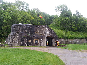
The Strongest Fort in Europe? by kingsnake In the late 1930s, Fort Eben-Emael was considered the strongest fort in Europe. It was one of four major forts of the Liege defense system meant to deter German land attacks across the River Meuse ("Maas" in Dutch). IN May, 1940, the Germans had other ideas, dropping paratroops on the bridges and Fort Eben-Emael. (The fort was essentially captured by a German fallschirmjäger platoon.) The bridges mostly captured -- bar one destroyed by a Victoria Cross-decorated RAF bomber crew -- and their defending fort neutralized, the German blitz was able to easily cross the river to exploit the tank country on the other side. Warning Being that this is an 70+ year old WWII battlefield, and they are still finding WWI shells a hundred years later, be careful about picking up any metallic objects you may find: You don't want to blow off any hands or feet.
You can hike the fortress perimeter any day of the year. You may even hike up above the fort, despite warning signs to the contrary. (At least according to our tour guide.) However, access to the inside of the subterranean fort is only allowed one weekend per month. See the fort's website at http://www.fort-eben-emael.be/en/ . There is a fee to enter, but not to walk around the outside. Unlike muh of Europe, parking is free. Hike The perimeter hike starts at the parking area by the fort's entrance. If it is a tour weekend, get there early as it will be packed by 1100, when the tours start. Check out the memorials outside the entrance, then start clockwise, to the northeast, along a paved path. As elsewhere in Belgium and the Netherlands, watch out for bikes. In .25 miles, you will come to the most accessible perimeter bunker. After .75 miles you will reach the Albert Canal. Turn right, passing to the right of the gate. For the next 1.5 miles, you will travel along the German-facing canal side of the fort. If the weather is rainy, the paved path will be muddy. Note the several bunkers along the cliff face. You may also see an ocean-going ship transitioning between the River Meuse and the Albert Canal. When you reach the cable-stayed bridge, turn right across the parking area. At this point you have a choice: Turn right up the stair trail, or continue up the brick road. The stair trail ends at a fence; if you decide to jump the fence and continue, you will end up atop the road as it exits the woods. If you instead go up the road, you are committed as the cliff the road winds up is vertical. At the top of the road, there is an observation point; a little past that. the road exits the woods. You have gone about 3.0 miles. Walk a half mile across the fields to a small cross-topped hill on your right. There is a "summit" log / geocache at the top of the 30-foot hill. After the hill wind down the road into the village of Eben-Emael. Turn right at the first intersection, going .30 miles back to the fort's parking area. Tour After your hike, on tour days, enter the fort, buy a ticket, and put in another mile or two, and several hundred feet AEG -- the stairs and ladders are steep -- touring the inside of the fort. Note that tours take about two hours. Gate Policy: If a gate is closed upon arrival, leave it closed after you go through. If it is open, leave it open. Leaving a closed gate open may put cattle in danger. Closing an open gate may cut them off from water. Please be respectful, leave gates as found. The exception is signage on the gate directing you otherwise. Check out the Official Route and Triplog. Leave No Trace and +Add a Triplog after your hike to support this local community. One-Way Notice This hike is listed as One-Way. When hiking several trails on a single "hike", log it with a generic name that describes the hike. Then link the trails traveled, check out the example. | |||||||||||||||||||||||||||||||||||||||||||||||||||||||||||||||||||||||||||


