 Route Editor

| Guide | ♦ | 1 Triplog | 0 Topics |
details | drive | no permit | forecast | route |
stats |
photos | triplog | topics | location |
| 59 | 1 | 0 |
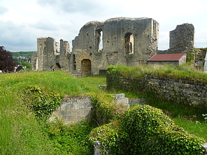
Castle Made of Sand by kingsnake Hike: You could spend a lot of time hitting the sights, or you could do this hike in the morning, learning the city, then in the afternoon hit the sites you saw a few hours earlier. The hike starts from one of the two major parking areas in the zentrum (city centre), at Walramplein. (Pay for your parking at the machine.)
After passing through the gate, you will begin the first of two minor climbs on the hike: About 200 feet in a .25 miles. The path will be extremely muddy if there has been recent precipitation, but it will be very peaceful with many birds chirping in the trees. When you reach the large pasture, turn right re-entering the woods. When you come to a rough road, turn right passing an abadoned tank trailer, until you hit pavement at Bergstraat ("Berg Street"). Turn left, as you enter Sibbe, you have gone 2.0 miles. As you enter Sibbe, split right up a farm lane, which passes through some *gorgeous* fields. Stay right along Heunsbergerweg, aiming for the cross-topped Kabelbaan tower. At the tower, you have gone 3.0 miles. Descend to the right of the mini-bobsled run (or whatever it is), turn left at the bottom, past the lift mechanicals, then descend to street level behind a hotel. You will exit near the Berkelpoort city gate. Turn left up the stairs behind the castle, then descend the west side of the castle, almost to the Grendelpoort, before turning up the Cauberg two lane road. (One of the few true teo lane roads in the city.) You have gone about 3.8 miles. Pass by the caverns on your right, taking the first split to the left. Making your only other climb of note, you will pass by the ampitheater masoleum, then the spa, arriving back on Cauberg just west of the casino. Cross the road, passing through a wood gate, onto the Heytgrachtvoetpad ("Heyt Canal Foot Path" -- ironically named as this is one of the few places in the country *without* a canal. When you again reach pavement at Plenkerstraat, you will have gone 5.0 miles. Turn right on Plenkerstraat, past the old Roman mines and back into the main part of town. This time pass through the Grendelpoort on the tourist strip. Take the first left down "Restaurant Row" (or as the Dutch call it, Grotestraat). This might be good time to enjoy some good beer. Pass the 14th century Sint Nicolaas en Barbara Kerk ("church") on your left, then cross ovet the Geul River to the old stadhuis ("city hall") on the right. Cross back to the south side of the Geul River, then continue east along the river walk to your car at Walramplein. You have gone about 5.9 miles. Gate Policy: If a gate is closed upon arrival, leave it closed after you go through. If it is open, leave it open. Leaving a closed gate open may put cattle in danger. Closing an open gate may cut them off from water. Please be respectful, leave gates as found. The exception is signage on the gate directing you otherwise. Check out the Official Route and Triplog. Leave No Trace and +Add a Triplog after your hike to support this local community. One-Way Notice This hike is listed as One-Way. When hiking several trails on a single "hike", log it with a generic name that describes the hike. Then link the trails traveled, check out the example. | |||||||||||||||||||||||||||||||||||||||||||||||||||||||||||||||||||||||||||


