Route Editor

| Guide | ♦ | 18 Triplogs | 0 Topics |
details | drive | permit | forecast | map |
stats |
photos | triplogs | topics | location |
| 441 | 18 | 0 |
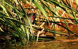
Wings over Wastewater by outdoor_lover  Overview OverviewMore birding opportunities abound in this little-known riparian area along the Salt and Gila rivers. This multi-functional facility located within the greater Phoenix area hosts a variety of birds year-round and provides a scenic, park-like setting, with views of the Sierra Estrellas and South Mountain. Warning Entry is by Permit Only.
In 2000, the Army Corps of Engineers, in cooperation with the Maricopa County Flood Control District and the City of Phoenix, embarked on the Tres Rios Ecosystem Restoration and Flood Control Project. The project encompasses 7 miles and approximately 1500 acres along the Salt and Gila River systems. Using highly treated effluent water from the City of Phoenix's 91st Avenue Wastewater Treatment Plant, the project involves a flood control levee, Emergent Wetlands, and an effluent pump station, as well as riparian and open water features, including large ponds and waterways. The project is home to several types of research, including Water Quality, Vegetation Sustainability, Mosquito Control, Non-lethal Beaver Control and Management, and Wildlife Diversity. Hike The hike/birding route follows a main road into the wetlands and then the road splits for a while. Take the left road first and then you eventually have to meet up with the main road again at a large waterway just below the dam. Walk up to the dam and cross going west as far as you want to go, enjoying the pond areas to your right. The road will eventually take you to Avondale Boulevard, following the Salt River and its eventual merge with the Gila River. You can make this trip as short or as long as you want, and even do a shuttle if you're so inclined, leaving a vehicle at the other end, where Avondale Boulevard turns and becomes Indian Springs Road at the Phoenix International Raceway. For more information on this wetland, visit www.tresrios.net Water Sources No Drinking Water Sources Camping Not permitted. Check out the Triplogs. Leave No Trace and +Add a Triplog after your birding observation to support this local community. | |||||||||||||||||||||||||||||||||||||||||||||||||||||||||||||||||||||||||||||||||||||||||||||||||||||||||||||||||||||||||||||||||||||||||||||||||||||||||||||||||