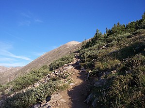
Hike: From the TH sign(10,850 ft) travel up the road a little ways and you'll see a small sign on the left. This marks the start of the trail. At this point, you are hiking through the forest. The trail from this route is Class 1 and easy to follow. The trail winds left and then south. When you see a large rock on the right side you will turn right and follow the trail signs and stay on the main trail. At around 11,300' you'll come cross a small clearing, this is where the trees start to become sparse. At this point, you'll probably stop and take a picture as I did. A little further ahead at about 11,700 ft you'll see a closed sign and trail going to the right. Stay on the main trail to the left, the one on the right is the old trail which is CLOSED. Follow this excellent trail as you continue on the East Ridge. Soon you will be leaving the trees,and you can now see the summit ahead.You will now go thru a section with rock stairs. Follow the trail to the top of the ridge, this is where I put on my winter hat and gloves(the wind was howling at this point). The last push to the summit is about a 1000' elevation gain. Summit elevation is 14,265 ft.
Summary: Quandary Peak will always be a hike remembered for a few reasons. First off it was my first 14er. Secondly, the people on the trail were great. Another reason was the rescue that happened the day before, and lastly meeting Horton the "Quandary Dog". Quandary is considered an "easy 14er", but descend down the wrong route and your easy hike can turn into a nightmare as it did for 3 people the day before I hiked this.
I hit the trail at about 6:30, and caught up with Travis and Chris who left the TH a little before me. Horton had chosen to hike with them. Horton lives nearby, and Summits Quandary often. He is an awesome well behaved, and "famous" dog. I hiked with them for quite a while and then continued my solo ascend. About 100 yards from the summit, the wind was really blowing and I stopped for a short time. I continued to the summit and stayed in a wind shelter for a while before heading down. Many people were ascending now as I was descending. Two people summited before me, and both of them ran the trail. One was a women who said "I wanted to get in a 14er before work". She was awesome!!! I summited in about 2 hours and 15 minutes. My descend took about 2 hours.
WARNING! Hiking and outdoor related sports can be dangerous. Be responsible and prepare for the trip. Study the area you are entering and plan accordingly. Dress for the current and unexpected weather changes. Take plenty of water. Never go alone. Make an itinerary with your plan(s), route(s), destination(s) and expected return time. Give your itinerary to trusted family and/or friends.
Permit $$
None
Directions
Road
FR / Dirt Road / Gravel - Car Okay
To hike From Denver I-70 West to Breckenridge then about 8-10 miles south on Colorado 9. Turn right on Blue Lakes 850 Road. A couple hundred yards turn right to McCullough Gulch 851. Drive straight to parking lot on right.
 Route Editor