username
X
password
register
for free!
help
   🔥

Butte Creek Trail - City of Prescott, AZ

Guide 7 Triplogs  0 Topics
  2.5 of 5  
Fav
Wish
0
details
drive
permit
forecast
🔥
route  
stats
photos
triplogs
topics
location
14 7 0
Statistics
tap row or icons for details
Difficulty 1.5 of 5
Distance Round Trip 2.6 miles
Trailhead Elevation 5,510 feet
Elevation Gain 345 feet
Kokopelli Seeds 4.33
 Interest Seasonal Creek
feature photo
Photos Viewed All MineFollowing
Inaugural Calculation on Button Tap!
17  2014-05-23
Thumb Butte Trail #33
kingsnake
14  2008-09-05 TwoWeims
Author
author avatar Guides 16,843
Routes 17,472
Photos 24
Trips 1 map ( 6 miles )
Age 28 Male Gender
Location HAZ, TrailDEX
Associated Areas
list map done
Prescott Region
Historical Weather
Trailhead Forecast
Radar Map
Expand Map
Preferred Apr, Oct, May, Nov
Sun  6:05am - 6:52pm
Official Route
 
2 Alternative
 
Historic Fire Perimeteracres
🔥 2018 Stubbs Fire34.7 mi**


remove free decal offer

Guide Needed
Publish Full Detail Guide


Use +Add above to share photos and triplogs
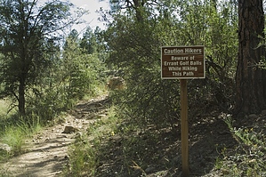
Overview: A city of Prescott trail connecting Stricklin Park to the Prescott National Forest trail system. The trail runs through Hassayampa country club golf course. It is 1.3 miles to the PNF Boundary. Continuing past the PNF boundary will lead to the Thumb Butte trail #33.


    Check out the Official Route and Triplogs.
    Leave No Trace and +Add a Triplog after your hike to support this local community.
    WARNING! Hiking and outdoor related sports can be dangerous. Be responsible and prepare for the trip. Study the area you are entering and plan accordingly. Dress for the current and unexpected weather changes. Take plenty of water. Never go alone. Make an itinerary with your plan(s), route(s), destination(s) and expected return time. Give your itinerary to trusted family and/or friends.

     Permit $$
    None

    Prescott Forest
    Prescott National Forest Pass

    Only trailheads with six "amenities" have fees. Amenities are picnic tables, trash, toilet, parking, interpretive signing and security.


     Directions
    or
     Road
    Paved - Car Okay

    To hike
    From downtown Prescott, take Gurley St. west to Thumb Butte Rd. Turn Left off Thumb Butte Rd. onto Sherwood St. As Sherwood St. curves to the right, Stricklin park will be on the left. Park along the side of the road.
    page created by TwoWeims on Sep 05 2008 9:15 pm
     90+° 8am - 6pm kills
    helpcorrectionissue

    end of page marker