Wheeler Peak has the option of a long and a short hike. The long hike is by the Bull of the Woods, and takes you over a greater length of everything involved. It also requires more time. Williams Lake to Wheeler Peak is much less of a hike and because it is off the ridge for most of the hike, it is a better option during windy periods or peaks in monsoon activity. Also, it is nice if you just don't want such a long hike.
The hike begins at the trailhead near the Bavarian. Follow the signs for Williams Lake tacked to the trees, or if not there, hike the road up slope. You hike past some pretty nice flowing water with some small falls, even though still in the ski area. Eventually, you'll arrive at a wood sign for the beginning of the trail. From here, it is an obvious foot path up through the spruce to Williams Lake, which is also a popular camping spot. Just before Williams Lake, a second sign directs you to the left and Wheeler Peak.
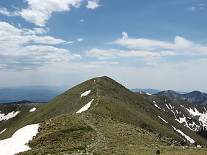
The second leg of the hike starts relatively easy and continues in the spruce forest. The forest cover begins to open up as you move to treeline and views improve. The switchbacks become less gradual and get a little steeper as you hike through the tundra. This is the hardest and steepest section of the trail, but it is very well built. Arriving at the saddle, turn right and head towards Wheeler Peak. Wheeler is about 1000' beyond the saddle and requires crossing a false summit. If you accidentally turn left. Mount Walter is 20 feet shorter and quite a bit closer. Walter also makes a nice second peak on your way down if not doing the longer shuttle loop hike. Return the way you came.
Distant views are at least as far as the Truchas group to the south, the Blanca Massif far to the north, and some of the higher peaks of the Southern San Juan Mountains to the northwest. While not anywhere near as high as the mountains to the north in Colorado, Wheeler is a pretty nice hike.
WARNING! Hiking and outdoor related sports can be dangerous. Be responsible and prepare for the trip. Study the area you are entering and plan accordingly. Dress for the current and unexpected weather changes. Take plenty of water. Never go alone. Make an itinerary with your plan(s), route(s), destination(s) and expected return time. Give your itinerary to trusted family and/or friends.
Permit $$
None
Directions
Road
FR / Dirt Road / Gravel - Car Okay
To hike rom the center of Taos, NM: Drive 4 miles north on NM 64 to the junction of NM 150 and NM64. Turn right onto NM150 and drive 15 winding road miles up to the upper parking lot of Taos Ski village. After the large welcoming sign on the left, turn into the large upper parking lot and follow it approx .3mls past this upper lot area to the Trail Head parking and Trail#90 start on the left side, just behind the wilderness information sign (Note: you are now at way point N36.59668 W105.44969); From this way point location "drive/follow the posted driving route" for 1.9 miles to end at the upper TH Parking and Trail Start for Williams Lake TR#62 (at way point N36.57938 W105.44003); The Williams Lake Trailhead is also where the Bavarian Restaurant is located.
 Route Editor