 Route Editor

| Guide | ♦ | 1 Triplog | 0 Topics |
details | drive | permit | forecast | 🔥 route |
stats |
photos | triplog | topics | location |
| 48 | 1 | 0 |
Oops, wrong hill by kingsnake   Notes Notes1) The object of this hike is referred to as Hill 6276 on CalTopo and US Topo, but MyTopo mistakenly refers to it as Hill 6292, which is the hill about a half-mile south of USMM 3275. 2) If you simply go up, then return the way you came, this is a great hike for dogs & kids.
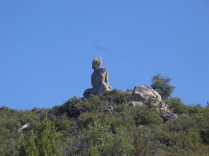
This hike starts at the large black gravel lot that is also the trailhead for Glen Oaks #118. From the lot, head north up Hwy 89 for about a hundred yards, crossing over to the jeep trail. (As of 2013, there is a memorial to Arleen Cilione there, as there has been since 2002.) A few feet up the jeep trail, it splits right towards a camping area and left. Go right through the camping area. From that point, you stick to the jeep trail. In some places, it is pretty smooth, but there are some rocky areas, so if you drive it, high clearance 4x4 is recommended. Walking, as I did, is not bad at all. It's 20 degrees cooler than Phoenix and has plenty of shade to boot. At about 0.5 miles, if you look to your right, you will see a rock formation that looks like a kneeling samurai. The terrain may look like an off-trail highway to your left -- nothing but pine needles and very light brush, but do not be fooled: The brush quickly gets very dense, and stabby, if you cut across country. At 1.3 miles, you will pass the shot-up vehicle roof. At 1.6 miles, will be the cement container for Board Creek Spring. It might have water in late winter / early spring, but in summer it is bone dry. At 1.8 miles, the trail again splits. Right is north towards Copper Basin Road Spring. Go left. A couple hundred feet further, the trail again splits. Left is towards Trap Corral Spring, which is also bone dry in summer. Stay right. At 2.1 miles, you will see a shot-up tree stump next to a large boulder. At 2.3 miles, there will be a large dead tree blocking the trail, but you can walk right up the middle of it without getting bopped on the head. At 2.5 miles, you will reach the top of Hill 6276, which is marked by a yellow Land Survey Monument sign. About a foot away from the pole is a rock etched "USMM" on the side, with an etched "X" on top: That is USMM 3275. There were no other marks or discs there that I could find, despite digging through the adjacent pile of rocks. There's great views from up there. You now have a choice: You can head back the way you came, or you can proceed off the south end of Hill 6276, down a narrow, stabby-strewn, trail. The trail is not noted on any map but is obvious on the satellite view. While it may appear the trail will eventually connect up with Glen Oaks #118, so you can make a loop, it does not. Instead, after about a .3 miles, by a cairn, it turns west, eventually descending a wash to a jeep trail two miles north of Wilhoit. So, no Glen Oaks #118 combo loop, unless you beat some serious, stabby, brush for a mile across (the true) Hill 6292. It is not the pine needle off-trail highway it appeared it would be when the hike started. Personally, after some stabbiness, I turned around. Check out the Official Route and Triplog. Leave No Trace and +Add a Triplog after your hike to support this local community. One-Way Notice This hike is listed as One-Way. When hiking several trails on a single "hike", log it with a generic name that describes the hike. Then link the trails traveled, check out the example. | |||||||||||||||||||||||||||||||||||||||||||||||||||||||||||||||||||||||||||||||||||||


