 Route Editor

| Guide | ♦ | 79 Triplogs | 0 Topics |
details | drive | permit | forecast | route |
stats |
photos | triplogs | topics | location |
| 560 | 79 | 0 |
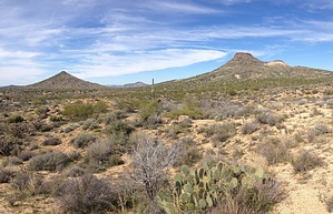
Straight shot through the desert by neilends  Overview OverviewAlthough Powerline Road #2 pierces a straight and therefore seemingly unentertaining line through the Preserve's northern section, this trail offers plenty of up-and-down hiking. It offers an excellent overview of the entire northern section. Warning This is a textbook desert hike. There is no relief from the sun and no water. Do not attempt this without ample water supplies and education about desert hiking.
The obvious appeal of this trail is that it offers a nice and simple through-hike from one trailhead to the other, west-east, of what's known as the MSP's "northern section." The distance of that route is, from Browns Ranch Trailhead to Granite Mountain Trailhead, using the Brown's Ranch Road, 3.5 miles one-way. It would be very difficult to get lost along the way, because of the total lack of any route-finding skills needed. The trail itself is very wide, and smooth, throughout. There are electric towers strung together with power lines (naturally) guiding you from above the entire way. The trail is also pretty popular, so you'll be seeing people frequently during the winter months. If solitude and a feeling of distance from civilization are what you seek, you won't find it here. But what you will get is a decent (light) cardio workout, due to the fair amount of vertical loops along the way. No major hill climbing. But a fair amount of ups and downs, despite the straight-arrow direction. You will also be rewarded with an excellent overview of the entire northern section of the MSP, with direct views along the way of Cone Mountain, Brown's Mountain, Granite Mountain, and all the others. There are connections to virtually every other trail for those wanting to explore deeper into the network, either north or south. For me, this was an ideal mountain bike route, given my hiking environment preferences. But to each their own. Water Sources Zero. Camping Not allowed.
Check out the Official Route and Triplogs. Leave No Trace and +Add a Triplog after your hike to support this local community. One-Way Notice This hike is listed as One-Way. When hiking several trails on a single "hike", log it with a generic name that describes the hike. Then link the trails traveled, check out the example. | ||||||||||||||||||||||||||||||||||||||||||||||||||||||||||||||||||||||||||||||||||||||||||||||||||||||||||||||||||||||||||||||||||||||||||||||||||||||||||||||||||||||||||||||||||


