Route Editor

| Guide | ♦ | 1 Triplog | 0 Topics |
details | drive | no permit | forecast | route |
stats |
photos | triplog | topics | location |
| 8 | 1 | 0 |
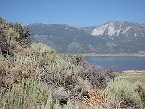
BewareThe Grim Reaper by AZLOT69  This is a Washoe County trail, but the trailhead is located at the ranger station for Washoe Lake State Park. Route finding will come into play as other than the trailhead there are no trail markings and the fast growing grasses camoflage the trail. There is ample parking but no facilities. The trail starts out by crossing a small wooden bridge over an often dry creek bed. The trail initially follows the roadway in a southerly direction in a historic manmade ditch used as a agricultural flume at one time. To the right lies Washoe Lake which is large but very shallow. Behind it to the west is the Sierra mountains highlighted by slide mountain named for its deadly rock slides. At about one mile the trail makes a sharp left turn up a canyon. This section is where all the elevation is gained. A small spring fed creek is on your right and has water year round. Much green foliage grows here and there are several placards to identify what you are seeing. If you go off trail in this area, caution is to be used as the creek area is full of stinging nettles. Stinging nettles is a bush with leaves that look like saw blades and can cause a lot of discomfort like a itchy insect bite. Ignore the trails that go off to the right and continue in a sweep around the hill on your left towards the north. A few switchbacks will have you meet with another trail. Stay left until you arrive at a dirt road. Just short of the road look left to find the trail hugging the hill. The trail starts down and as it comes around the north end enjoy the distant views of the Sierra. A few switchbacks will bring you within sight of your vehicle. The loop continues down to meet the trail you started on. Check out the Official Route and Triplog. Leave No Trace and +Add a Triplog after your hike to support this local community. | ||||||||||||||||||||||||||||||||||||||||||||||||||||||||||||||||||||||||||||||||||