Route Editor

| Guide | ♦ | 1 Triplog | 0 Topics |
details | drive | no permit | forecast | route |
stats |
photos | triplog | topics | location |
| 15 | 1 | 0 |
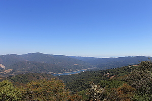
Nice Exercise by JimmyLyding  The hike starts at the small trailhead at the end of Montevina Road a few miles north of Lexington Reservoir and Hwy. 17. The Montevina Ridge Trail heads due north and uphill from the trailhead about 1/4 mile to the Aquinas Trail. Go right/east on Aquinas for 1.7 miles as it travels downhill from Monte Sereno, the high point of the hike at a shade over 2,500'. There are great views of Mount Umunhum to the south and Monterey Bay so the southwest along this stretch. You'll reach a junction with the Loma Vista Trail which heads down to the north to the end of a dirt road, and continue on Aquinas for about a half-mile to a junction with the Serenity Trail. Serenity heads down to a lookout about 1.3 mile away while Aquinas continues almost 2 miles due east to the end of another dirt road.
This park is popular with mountain bikers, and there are numerous side-ramps, or whatever they're called, that cyclists use to get in a little extra fun, and to slow down their descent. Check out the Official Route and Triplog. Leave No Trace and +Add a Triplog after your hike to support this local community. | ||||||||||||||||||||||||||||||||||||||||||||||||||||||||||||||||||||||||||||||||||