username
X
password
register
for free!
help
 

San Francisco Bay Bridge, CA

Guide 3 Triplogs  0 Topics
  4 of 5  
Fav
Wish
0
details
drive
no permit
forecast
map
stats
photos
triplogs
topics
location
6 3 0
Statistics
tap row or icons for details
Distance One Way 0.75 miles
Trailhead Elevation 11 feet
Elevation Gain 50 feet
Accumulated Gain 75 feet
Kokopelli Seeds 1
 Interest Historic
feature photo
Photos Viewed All MineFollowing
150  2013-10-25
San Francisco Tour - October 2013
Randal_Schulhaus
6  2013-07-17 Randal_Schulhaus
Author
author avatar Guides 16,843
Routes 17,472
Photos 24
Trips 1 map ( 6 miles )
Age 28 Male Gender
Location HAZ, TrailDEX
Historical Weather
Trailhead Forecast
Expand Map
Preferred Oct, Jun, May, Jul
Sun  5:43am - 6:33pm
0 Route
 
0 Alternative


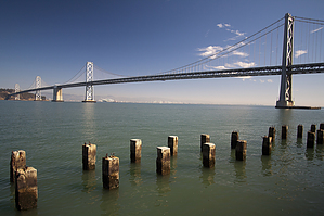
Bay Bridge construction began July 9, 1933 and opened November 12, 1936.

The cost of the original bridge was $77 million in 1936 (included Transbay Transit Terminal)


Key System trains operated on the bridge from 1938 to 1958. In 1962 the bridge was reconfigured to carry cars and trucks only.
remove free decal offer


    Check out the Triplogs.
    Leave No Trace and +Add a Triplog after your walk/tour to support this local community.
    WARNING! Hiking and outdoor related sports can be dangerous. Be responsible and prepare for the trip. Study the area you are entering and plan accordingly. Dress for the current and unexpected weather changes. Take plenty of water. Never go alone. Make an itinerary with your plan(s), route(s), destination(s) and expected return time. Give your itinerary to trusted family and/or friends.

     Permit $$
    None


     Directions
    or
     Road
    Paved - Car Okay

    To walk/tour
    page created by Randal_Schulhauser on Jul 17 2013 4:46 pm
     90+° 8am - 6pm kills
    helpcorrectionissue

    end of page marker