The Aspen Trail #411 begins at Carr Lake Trailhead and ends at Carr Lake Trailhead. The Aspen trail forms "loop A", the red loop of the Carr Lake Trail System. After the trail passes the end of trail #412, it travels past an enclosed fence built to keep elk out of an area to protect young aspen trees. The General Crook Trail follows this trail briefly from Carr Lake Trailhead.
When hiking several trails on a single "hike", log it with a generic name that describes the hike. Then link the trails traveled, check out the example.
WARNING! Hiking and outdoor related sports can be dangerous. Be responsible and prepare for the trip. Study the area you are entering and plan accordingly. Dress for the current and unexpected weather changes. Take plenty of water. Never go alone. Make an itinerary with your plan(s), route(s), destination(s) and expected return time. Give your itinerary to trusted family and/or friends.
Permit $$
FS
Directions
Road
FR / Dirt Road / Gravel - Car Okay
To hike From the intersection of Route 260 and Rim Road (FR300), at the Rim Vista Visitors Center, travel FR 300 West aprox 5.5 miles. Turn left to reach the TH.
 Route Editor

 The Aspen Trail #411 begins at Carr Lake Trailhead and ends at Carr Lake Trailhead. The Aspen trail forms "loop A", the red loop of the Carr Lake Trail System. After the trail passes the end of trail #412, it travels past an enclosed fence built to keep elk out of an area to protect young aspen trees. The General Crook Trail follows this trail briefly from Carr Lake Trailhead.
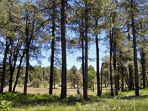


