Route Editor

| Guide | 0 Triplogs | 0 Topics |
details | drive | no permit | forecast | route |
stats |
photos | triplogs | topics | location |
| 14 | 0 | 0 |
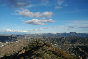
Short and Steep by slegal  There are two different ways to the top that I’m aware of. One access point is located at N 34° 8'4.49" W118°45'26.25" off of Kanan Rd. The other, which is the route that is covered in this description, is located further up Kanan Rd. The primary difference between the two routes is that the route that starts at the first starting point is longer, has more elevation gain, but isn’t as steep as the route in this description.
There is a short section about a quarter of the way up where you can head straight up a steep scramble or head left to a switchback that isn’t as steep, but is very loose and heavily eroded. Both routes join together again at the top of the scramble. From the top of the scramble, the trail heads straight up to the top of Ladyface on a fairly steep slope. Since it is only 800 feet of elevation gain the climb is over before you know it. The hike distance is only to the top of the peak. There is a game trail that runs along the ridge either east or west of the peak and it is worth exploring. Check out the Official Route. Leave No Trace and +Add a Triplog after your hike to support this local community. | ||||||||||||||||||||||||||||||||||||||||||||||||||||||||||||||||||||||||||||||||||