The Barker Pass Trailhead is located between the Desolation Wilderness and the Granite Chief Wilderness in the Sierra Mountains. This is a multi use trailhead with several OHV trails in this area. Mountain bikers also have various trails and frequent the area.
This hike is a section of the Tahoe Rim Trail and it is shared with the Pacific Crest Trail. There are no motor vehicles and no bicycles allowed on this section of the TRT.
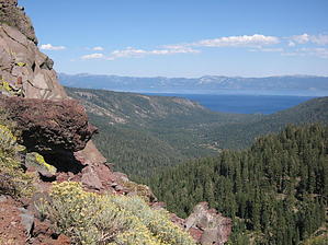
The hike starts its climb right from the beginning. It's a slow but steady climb and provides a nice warm up. A heavy cover of trees provide plenty of shade as distant views of the Sierra divert your attention from the trail. Your heart sets into a rhythm about the time you pass by Barker Peak and you get your first views of distant Lake Tahoe to the east. In the morning light it may be hard to distinguish the lake from the mountains that silhouette it from behind. You leave the cover of the forest and cross a meadow of lilies... often flowering late into the season. Ahead is a dramatic volcanic outcropping which provides ample opportunities for photography. Be alert as the trail drops off to the left of the outcropping and starts a descent. To the north your destination of Twin Peaks is prominent on the horizon. After gaining about 500 feet, you give it all back as you serpentine down crossing several spring fed streams that still had ample flow in September. The wild flowers were still plentiful around the water. As you cross the valley there are several views of Lake Tahoe. Back in the trees you must gain about 700 feet in the next mile. This is accomplished with a serpentine that is comfortably graded. Near the top you lose the tree cover and the trail becomes a path thru the scree. Shade is scarce on top but the panoramic views in all directions is awesome. At 4.94 miles the Tahoe Rim Trail makes a right turn towards Twin Peaks. The Pacific Crest Trail continues straight ahead. It is a marked intersection but the sign was rather flimsy. Continue on the TRT .50 miles to the base of Twin Peaks. Bag it or not and return the way you came.
When hiking several trails on a single "hike", log it with a generic name that describes the hike. Then link the trails traveled, check out the example.
WARNING! Hiking and outdoor related sports can be dangerous. Be responsible and prepare for the trip. Study the area you are entering and plan accordingly. Dress for the current and unexpected weather changes. Take plenty of water. Never go alone. Make an itinerary with your plan(s), route(s), destination(s) and expected return time. Give your itinerary to trusted family and/or friends.
Permit $$
None
Directions
Road
FR / Dirt Road / Gravel - Car Okay
To hike Take Highway 89, 5 miles south of Tahoe City, California. At Kaspian Beach watch for a road on the right marked Blackwood Canyon. Take Blackwood Canyon Road for 6.7 miles of pavement. Then .50 miles further on gravel. Trailhead is a signed parking lot on the right which accomodates about 20 cars. Restroom available but no water.
 Route Editor


