Route Editor

| Guide | ♦ | 2 Triplogs | 1 Topic |
details | drive | no permit | forecast | route |
stats |
photos | triplogs | topic | location |
| 10 | 2 | 1 |
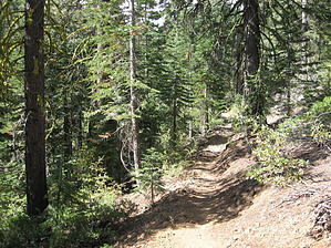
Turn The Page by AZLOT69 The trail starts at the southwest corner of the parking area and follows the Truckee river in a westerly direction. The clear cool water of the Truckee is inviting and would feel good after a hike and your feet are barking. In about one third of a mile the trail has a Y. Take the left trail and it starts up thru a thick old heavily forested area. The initial climb is steady, eased by a few switchbacks. Off to the left you catch the occasional glint of civilization as the sun glares off an auto or some metal. At the next junction turn right. The grade eases now but the trail has a gradual grade up for the next two miles. You might find yourself looking left and back anticipating views of Lake Tahoe. Unfortunately the forest is so thick this section of the TRT offers no clear view of the lake. At the next junction turn right again. The forest has been thinned here and nice views of the volcanic rocks towering above on the right are inspiring. The next junction we take to the left. In this area there is some aggressive tree management taking place in an effort to avoid forest fires. Soon you arrive at Paige Meadows. A beautiful wetland area which in spring has a wealth of wildflowers. But beware it also has a bounty of mosquitoes. The trail joins an old narrow jeep road just past the meadow. Keep right at the junction and soon views of twin peaks are ahead. The grade down begins for the next three quarter mile and you arrive at Ward Creek Blvd. Go east on Ward Creek Blvd 2.5 miles to the Lakeside trail, a paved bicycle trail.
Check out the Official Route and Triplogs. Leave No Trace and +Add a Triplog after your hike to support this local community. | ||||||||||||||||||||||||||||||||||||||||||||||||||||||||||||||||||||||||||||||||||