 Route Editor

| Guide | ♦ | 1 Triplog | 0 Topics |
details | drive | permit | forecast | route |
stats |
photo | triplog | topics | location |
| 1 | 1 | 0 |
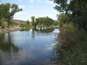
It Ought To Be Illegal by AZLOT69  The hike starts at the Carson River Park. Almost immediately you cross a walk thru and onto private property. This is Silver Saddle Ranch, a working ranch in which BLM and the city of Carson City have worked out an agreement for access. The Carson River on your left creates a ribbon of green as it passes thru the desert. Lined with ancient cottonwood trees, the corridor thrives with wildlife. The river originates near Carson Pass high in the Sierra and is fed by melting snows. A raging river in the spring, the flow slows to a trickle late in summer as the snows diminish. The trail is on the tailings of the Mexican Ditch diggings. It's a great family trail as its smooth and not much altitude change. Prison Hill is to your right and the Pine Nut Mountains are to the left. Animal trails can be seen both right and left along the way as they access the water. The trail ends at the Mexican Dam. The Dam built in 1860 diverts some of the Carson River water to the Mexican Ditch. Most of the original dam is still there built from stone. It is over one hundred feet wide and fifteen feet high and has been compromised by floods many times. Lacking formal funding, the farmers do makeshift repairs using anything they can find and concrete to reinforce the dam. Many such repairs are tagged with initials and dates. Old tree trunks and wood timbers are placed against the wall trying to keep it in place. The dam is comfortably wide enough to walk across the river and get a closer examination. Perhaps after a snack return the way you came. Check out the Official Route and Triplog. Leave No Trace and +Add a Triplog after your hike to support this local community. One-Way Notice This hike is listed as One-Way. When hiking several trails on a single "hike", log it with a generic name that describes the hike. Then link the trails traveled, check out the example. | ||||||||||||||||||||||||||||||||||||||||||||||||||||||||||||||||||||||||||||||||||


