The Mount Judah Loop is accessed off the Pacific Crest Trail(PCT) south of Donner Pass. Highlights of this hike are the magnificent views of Donner Pass and Donner Lake, bagging Donner Peak and Mount Judah, the distant views of the city of Truckee, Mt Rose, Coldstream Canyon, Anderson Peak, Tinker Knob, Castle Peak and the Sierra Buttes. If you are like me you will already be planning your next adventure with any of the fore mentioned being suitable destinations.
The many features named Donner reflect the homage paid to the fated Donner party who had the misfortune of encountering a one hundred year snowstorm on their attempt to cross these mountains with their wagon trail enroute to California in 1846. The group led by George Donner was behind schedule due to a series of mishaps and arrived here in November. Much of the notoriety of the story revolves around the implication that the group resorted to cannibalism to survive the winter. Only 40 of the 87 people survived.
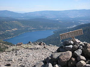
The trail starts with an initial steep climb up a granite precipice. After the initial climb the trail follows the contour of the mountain as it circles around to the south and east. To the west lies Lake Mary, a pretty little reservoir. There are ski lifts in practically every direction on surrounding hillsides as this is perhaps the most popular snow play area in the North Tahoe area. The Mt Judah loop can be accomplished in either direction but is described here in a clockwise fashion. At about one mile take a left at your first intersection. The trail takes a long switchback with a gradual incline as you enter a forested area. The trail comes out to an old wagon road and taking it you continue up the grade. Arriving at a saddle you notice Donner Peak to your left. You would be remise not to explore this area. The Granite features of Donner Peak far outdo its higher neighbor of Mount Judah. Donner Peak requires a scramble and you can make it a difficult climb depending on your approach. The vegitation struggles here to survive. After exploring retrace your steps to the saddle and continue on to Mount Judah. It is a moderate climb and you can see your destination ahead as you leave the forest growth. Mount Judah is on a relatively featureless ridge, but the views are awesome. Its generally windy with no relief on top so you may continue down the south slope for some shelter. The trail passes several volcanic outcroppings on this side as the trail switchbacks down to meet the PCT. At the junction turn right. The PCT will take you back to the trailhead.
WARNING! Hiking and outdoor related sports can be dangerous. Be responsible and prepare for the trip. Study the area you are entering and plan accordingly. Dress for the current and unexpected weather changes. Take plenty of water. Never go alone. Make an itinerary with your plan(s), route(s), destination(s) and expected return time. Give your itinerary to trusted family and/or friends.
Permit $$
None
Directions
Road
FR / Dirt Road / Gravel - Car Okay
To hike Trailhead Coordinates: N39° 18.981' W120° 19.585'
Exit I-80 at Soda Springs or Donner Lake and take the historic Lincoln Highway (US 40) to Donner Pass. Go 6 Miles east of Soda Springs, or 6 miles west of Donner Lake. On the south side of the road is the Sugar Bowl Academy for climbers. Take the road south out of their parking lot one half mile to the trailhead. Parking is just past the trailhead and limited.
 Route Editor