Route Editor

| Guide | ♦ | 22 Triplogs | 1 Topic |
details | drive | no permit | forecast | 🔥 route |
stats |
photos | triplogs | topic | location |
| 345 | 22 | 1 |
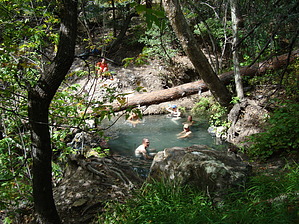
mmm...hot springs... by writelots  Begin the hike on the Little Bear Canyon Trail at TJ Corral near the Gila Cliff Dwellings National Monument. If you're bringing two cars, it helps to leave one at the Nat. Monument visitor center (where the trail ends). The Little Bear Canyon trail beings with a gentle ascent up the plateau, quickly gaining some magnificent views across the Mogollon Range. Threading through junipers and pinon pines, you'll make your way gradually to a minor drainage and follow it to it's headwaters at a low saddle. This climb takes about 2 miles and gains around 750', and it's the only real up hill along the whole hike. Congrats!
From here, cross the stream, turn left (upstream) and follow the Middle Fork for another 2 miles to the spring. This area is beautiful, with rock spires and vertical canyon walls, lush riparian vegetation and the river itself - a crystal clear babbling watercourse with a fair number of smallish trout and other fishies. Water levels vary from mid-calf to nearly waist high depending on the time of year - and you'll have as many as 15 crossings between the confluence and the springs (the trail changes some from year to year depending on flooding and stream course changes). The spring itself is up a little ways on a steep path. A small stone dam creates a crystal clear pool just the right depth for soaking in - and it's filled by a small, warm waterfall. A canopy created by a beautiful tree completes the picture perfect spot. The hot spring is really more of a warm spring - I've heard reports of between 99 and 100 degrees. Nice for soaking in without turning into a prune. Please leave this spot as pristine as you found it - candle wax isn't a part of my prefered wilderness experience. There are a number of prime camping spots along this stretch - many of them tucked under pines and sycamores just off the water's edge. But hold out - there's plenty of good camping closer to the main attraction. You'll know you've reached the hotspring when the trail crosses a maze of warm streams descending the canyon wall. If the most obvious camping spots are taken, keep walking - there are more just across the creek. After enjoying your soak and spending a blissful night under the sycamores - begin back the way you came. When you reach the conflunce of Little Bear and the Middle Fork, keep to the main stream course and follow it back to the visitor center. The trail will cross the river many, many more times as the canyon opens up and the walls soften to rounded hills. About 7 miles from Jordan is Gila Hot Springs. This spring is very hot - it comes out of the ground at around 130 degrees - so be careful. Bathers frequently dig pools in the main watercourse to mix the spring water with the cooler river water - but these pools are typically very shallow and muddy, and there is no vegetation around the spring. After Jordan, it seems like a nasty, unappealing spot that we usually just admire from afoot. About a mile further down the trail, there is a roadbed heading up a hill on the left riverbank (as you face downstream). Follow this road up to the visitor center parking area. If you didn't leave a car here, it's another mile along the paved roads to the TJ Corral.
Check out the Official Route and Triplogs. Leave No Trace and +Add a Triplog after your hike to support this local community. | ||||||||||||||||||||||||||||||||||||||||||||||||||||||||||||||||||||||||||||||||||||||||||||||||||||||||||||||||||||||||||||||||||||||||||||||||||||||||||||||||||||||||||||||||||||||||||||||||||||||||||||