Route Editor

| Guide | ♦ | 38 Triplogs | 0 Topics |
details | drive | permit | forecast | route |
stats |
photos | triplogs | topics | location |
| 213 | 38 | 0 |
Climb to the top of Texas by Jim The Guadalupe Peak trail is a well marked and established trail. It gets lots of maintenance attention and is in excellent shape. This makes sense since it is the states highpoint. However, given the population of Texas the peak gets few visitors. This is probably due to it's isolation. Another reason may be the difficulty of the trail. For an in-shape Arizona hiker it would be nothing more than an enjoyable day hike, but I think for a sedentary person from Houston it may be the "hike of a lifetime".
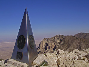
There is a junction with a couple of other trails after the first 1000' of hiking. One of the side trails is a horse route that rejoins the main trail further up the mountain. It is less steep than the section it avoids, but you will still have to climb up a significant portion of the first 1200' of elevation. It is designed for horses, so it might not do you much good to take it. The other trail you will meet up with is the spur to the back country campground. This is about 1 & 1/2 miles before the summit. The campground is primitive and free (permit required). There is no water, no toilets, and it is pack-in pack-out. Still, it is a nice place to spend the night. I enjoyed it when I did so in July of 2007. The best part about it was that you can set up your camp and then hike on to the summit to cook dinner and watch the sunset. You'll need a camp stove to cook in the park as there are no fires allowed. The summit is marked with a large metal pyramid to note the Butterfield Stage Route that ran near the base of the mountain. The peak seems very high. But it isn't even 9000'. Mostly, the desert that is 4000' below makes you feel really high. The vegetation will tell a different story- its Pinyon and Juniper on the summit. The thing I love about this mountain is that it is SMALLER than every other western mountain I have been up. So it would seem that unlike waistlines and gas guzzling vehicles, NOT everything in Texas is bigger. Ha!! Actually, all the Texans I have met on the trail are very friendly and happy to be up on their highpoint. Come to think of it though, in the 3 times I have climbed the Peak I have barely ever met any people on the trail. Odds are you won't see many people either. From my personal experiences of climbing in August 2003, October of 2005, and July of 2007, the numbers of people on the trail is more like Humphrey in winter than in summer. Unless things have changed, relax enjoy some time alone.
Check out the Official Route and Triplogs. Leave No Trace and +Add a Triplog after your hike to support this local community. | ||||||||||||||||||||||||||||||||||||||||||||||||||||||||||||||||||||||||||||||||||||||||||||||||||||||||||||||||||||||||||||||||||||||||||||||||||||||||||||||||||||||||||||||||||||||||||||||||