username
X
password
register
for free!
help
 
  🔥

Inspiration Point - Tonto NF, AZ

Guide 4 Triplogs  0 Topics
  3.5 of 5  
Fav
Wish
1
details
drive
no permit
forecast
🔥
route  
stats
photos
triplogs
topics
location
15 4 0
Statistics
tap row or icons for details
Difficulty 2.5 of 5
Route Finding 3 of 5
Distance One Way 1.5 miles
Trailhead Elevation 1,864 feet
Elevation Gain 625 feet
Accumulated Gain 837 feet
Avg Time One Way 3 hours
Kokopelli Seeds 4.29
 Interest Peak
 Backpack Yes & Connecting
 Dogs not allowed
feature photo
Photos Viewed All MineFollowing
3  2010-10-31 dandrayan
12  2008-10-05 AZLOT69
Author
author avatar Guides 177
Routes 249
Photos 10,213
Trips 2,215 map ( 17,459 miles )
Age 74 Male Gender
Location Gold Canyon, AZ
Associated Areas
list map done
Phoenix Region
Historical Weather
Trailhead Forecast
Radar Map
Expand Map
Preferred Feb, Jan, Dec, Mar → 8 AM
Seasons   Late Autumn to Late Spring
Sun  6:02am - 6:46pm
Official Route & 1 Rt
 
1 Alternative
 
Historic Fire Perimeteracres
🔥 2024 Siphon Fire35.9 mi*


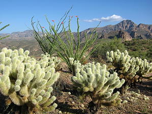
At The Cliff Your Up The Creek
by AZLOT69

 
Overview
The Tortilla Flat area has long been quoted as an inspirational point for poets and writers. Its location along the Apache Trail sandwiched between the Superstition Wilderness on its south and the Four Peaks Wilderness to its north make it unique. Access by motor vehicle allows you to step back in time, experience the wilderness and be home for dinner. The road now known as the Apache Trail has long been used as a way thru these mountains. The Apache passed this way on hunting parties and raids against competing interests. Later use by hunters, miners and ranchers have left legendary stories of its past.


Hike
The hike starts just east of the Mesquite Creek crossing of SR 88 one mile east of Tortilla Flat. About 100 feet north of SR 88 cross the creek towards the northwest on an old jeep trail and then veer left at the Y and start up. The moderate climb up the jeep road ends at about one-quarter mile. A faint trail then continues up. Use your route finding skills as up is the direction. It becomes a steep climb and other than two or three cairns, the unmarked trail is fairly easy to follow. Toward the top, the trail eases and follows a contour around the south side of the cliffs looming ahead. Ahead on the left is a mountain that appears to be a peninsula with sharp cliff sides. It's about three-quarters of a mile long, and fairly flat. Although it did not look accessible earlier in the hike as you approach the saddle, you are pleasantly surprised that it can be done.
remove free decal offer
The saddle ends the majority of the climb but take the time to top it off by heading to the high point to the right. It is only about a quarter-mile to 2493. Offered are great views of the Mesquite Y with Four Peaks in the distance. Truly an overlook of the wilderness. Vegetation is sparse but accent plants are mature and healthy. Now head back to the saddle and around the southwest side of the peninsula. There is no trail but follow the contour and head in a southeast direction. In about three-quarters of a mile, you come to the cliff's edge, Inspiration Point. To the west lies Canyon Lake. Southwest below is Tortilla Flat. South lies Tortilla Creek winding into the Superstition Wilderness. In the background lie Tortilla Mountain and Malapais. Can you name any others? Look east at the mountainous landscape punctuated by Castle Dome. While civilization is near and an occasional car may pass far below on SR 88 you will be inspired by the beauty and reflect on the history that passed this way. Return the way you came.

2008-10-06 AZLOT69


    Check out the Official Route and Triplogs.
    Leave No Trace and +Add a Triplog after your hike to support this local community.

    One-Way Notice
    This hike is listed as One-Way.

    When hiking several trails on a single "hike", log it with a generic name that describes the hike. Then link the trails traveled, check out the example.
    WARNING! Hiking and outdoor related sports can be dangerous. Be responsible and prepare for the trip. Study the area you are entering and plan accordingly. Dress for the current and unexpected weather changes. Take plenty of water. Never go alone. Make an itinerary with your plan(s), route(s), destination(s) and expected return time. Give your itinerary to trusted family and/or friends.

     Permit $$
    None


     Directions
    or
     Road
    Paved - Car Okay

    To hike
    From Apache Junction take SR88 1.1 miles east past Tortilla Flat. Just after the road goes thru the dip of the wash turn left on the next dirt road and park about 100 feet in at the first turn around.
    page created by AZLOT69 on Oct 06 2008 10:04 am
     90+° 8am - 6pm kills
    helpcorrectionissue

    end of page marker