Route Editor

| Guide | ♦ | 22 Triplogs | 1 Topic |
details | drive | no permit | forecast | map |
stats |
photos | triplogs | topic | location |
| 156 | 22 | 1 |
Canyons are inherently risky. Flash floods occur without notice on sunny days. Technical skills & surrounding topography knowledge required yet does not eliminate risk.
Come see where the hell the Hell came from! by JoelHazelton  Ever since I first found out about the Hells Canyon Wilderness, its namesake destination has been on my to-do list. Now that it is open to the public, I finally got my chance to check it out! What I was originally hoping for was the west valley's answer to the Lower LaBarge Box. If you check out the canyon on a topo map you would understand why I was thinking this. While it isn't quite as awesome as LaBarge, it's certainly worth a visit. Ever since I first found out about the Hells Canyon Wilderness, its namesake destination has been on my to-do list. Now that it is open to the public, I finally got my chance to check it out! What I was originally hoping for was the west valley's answer to the Lower LaBarge Box. If you check out the canyon on a topo map you would understand why I was thinking this. While it isn't quite as awesome as LaBarge, it's certainly worth a visit.The hike begins in a very scenic little area called Cedar Basin. If you are searching for a great car camping destination in the desert, it doesn't get much better than this. It's a stark contrast to the previous drive, with creosote bushes, chaparral, and even a few junipers scattered about. The views of the wilderness are huge, and sunset/sunrise here would likely be unbeatable.
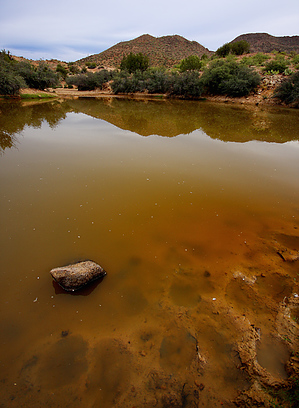
At this point, the bottom of Garfias Wash is very broad and filled with vegetation, although there is a sandy creek bottom that is clear of vegetation that winds through the brush. Once you spot this, hop on and start walking downstream. It's a bit difficult to stay in the main creekbed, but soon the wash will narrow and travel will become much easier. To your left is Hellgate Mountain, and the rocky, steep peaks of its ridgeline lead down to the bottom of the wash up ahead of you. Garfias Mountain looms to the right but isn't as impressive as Hellsgate and its companions. Both are just begging to be climbed. It would be worth it to check to see if they are on private property before attempting them, though. Continue downstream and the slopes of Hellsgate and Garfias Mountain start to close in on you. Just over a mile in they meet and you enter a very narrow section of the canyon. Here it is necessary to scramble off a 3-4 foot ledge in order to continue. Although this isn't very difficult for most, it will weed out those hikers with really bad knees or ankles. You will most likely have to hop a couple of feet off, and on the return, you must pull yourself up with your arms. Because of the steep and narrow nature of the canyon at this point, there isn't a logical alternative to this. After the ledge is passed the vegetation thickens again and travel is easier on creek right for this section. Soon, after you are past the impressive slopes of Garfias and Hellsgate Mountains, the creekbed widens a bit as it slowly bends south. The gates of Hell Canyon proper come into view and the anticipation builds. There is one final sharp bend to the east before you enter the canyon. There appears to be a path leading up and over the floodplain on creek left that cuts this turn, but it's not worth it. Cows are generally not as tall as people and it is apparent on this path when you're getting stuck in the face by prickly branches. The narrow canyon is a riparian area with tall, steep walls and perennial water. It had not seen any precipitation for almost two months when I was there and there were large pools of stagnant water connected by small seeps. During the rainy season, it would probably be a very pleasant canyon. With all of the vegetation, the water, and the cows, the smell is rather pungent in the canyon. Travel through the canyon is rather difficult and requires scrambling along the ledges on creek right. I didn't explore very far down the canyon because of time constraints, but it appears to twist and turn for about a half mile before it opens back up again. Be careful about hiking farther east than Hell Canyon; word has it this is private property. After you're done exploring Hell Canyon, return the way you came. This is a rather short hike, but there is plenty more to explore in the area. Climb one of the peaks or hike the Burro Flats Loop. I know I'll be back for an overnighter in Cedar Basin and some more exploration. Gate Policy: If a gate is closed upon arrival, leave it closed after you go through. If it is open, leave it open. Leaving a closed gate open may put cattle in danger. Closing an open gate may cut them off from water. Please be respectful, leave gates as found. The exception is signage on the gate directing you otherwise. Check out the Triplogs. Leave No Trace and +Add a Triplog after your canyon trip to support this local community. | |||||||||||||||||||||||||||||||||||||||||||||||||||||||||||||||||||||||||||||||||||||||||||||||||||||||||||||||||||||||||||||||||||||||||||||||||||||||||||||||||||||||||||||||||||||||