Route Editor

| Guide | ♦ | 3 Triplogs | 0 Topics |
details | drive | no permit | forecast | route |
stats |
photos | triplogs | topics | location |
| 12 | 3 | 0 |
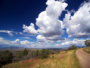
canyons, cows, and cosmos by PrestonSands   This short and scenic loop near the Arizona-New Mexico border takes in the rolling hills and forested valleys of the Big Lue Mountains. Solitude is almost a certainty in this out of the way country. Colorful wildflowers and verdant hills make late summer an ideal time to hike this loop. This short and scenic loop near the Arizona-New Mexico border takes in the rolling hills and forested valleys of the Big Lue Mountains. Solitude is almost a certainty in this out of the way country. Colorful wildflowers and verdant hills make late summer an ideal time to hike this loop.Beginning at Forest Road 212's crossing of Seep Spring Canyon, a very faint old jeep road heads west up Seep Spring Canyon into a Ponderosa Pine forest. The old road soon disappears in the narrow canyon bottom, but one only needs to follow the creek bed to stay on route.
A few hundred yards past the fork, the old road reappears on the canyon's right (north) side. Begin following the road again. After passing a couple of abandoned metal water troughs, the road reaches a switchback, where, directly below, a rusted 1940's era car lies wrecked in the creek bed. The old road bends right at the switchback and climbs a rocky, basaltic hillside into juniper grassland. Sturdy boots help negotiate the numerous spherical rocks that cover the road surface. Openings in the trees allow for distant views of New Mexico's mighty Mogollon Mountains. Turning north, the road crests an open, grassy mesa at 1.5 miles, where it encounters a side road to the left. Go straight. You are now on Forest Road 212A. Heading downhill to the north, Forest Road 212A soon arrives at a junction with a side road to Maverick Tank. Stay left. Forest Road 212A (signed) terminates at its junction with Forest Road 212 (Martinez Ranch Road) at the hike's 1.9-mile point. Turn right (east) onto Forest Road 212. The road now contours east through juniper-oak grassland that affords outstanding views of the rolling Arizona-New Mexico borderlands. The bluish silhouette of the White Mountains dominates the skyline to the north. At around 2.5 miles, the road begins a steady descent off the mesa, eventually turning south to make a gradual drop into Big Lue Canyon. Wide-open views of the upper Big Lue valleys and Maverick Peak keep the hike interesting. The 3.3-mile point brings one back to their starting point on Forest Road 212, at the bottom of Seep Spring Canyon. Check out the Official Route and Triplogs. Leave No Trace and +Add a Triplog after your hike to support this local community. | |||||||||||||||||||||||||||||||||||||||||||||||||||||||||||||||||||||||||||||||||||||