 Route Editor

| Guide | ♦ | 26 Triplogs | 0 Topics |
details | drive | no permit | forecast | 🔥 route |
stats |
photos | triplogs | topics | location |
| 120 | 26 | 0 |
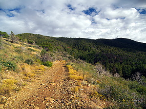
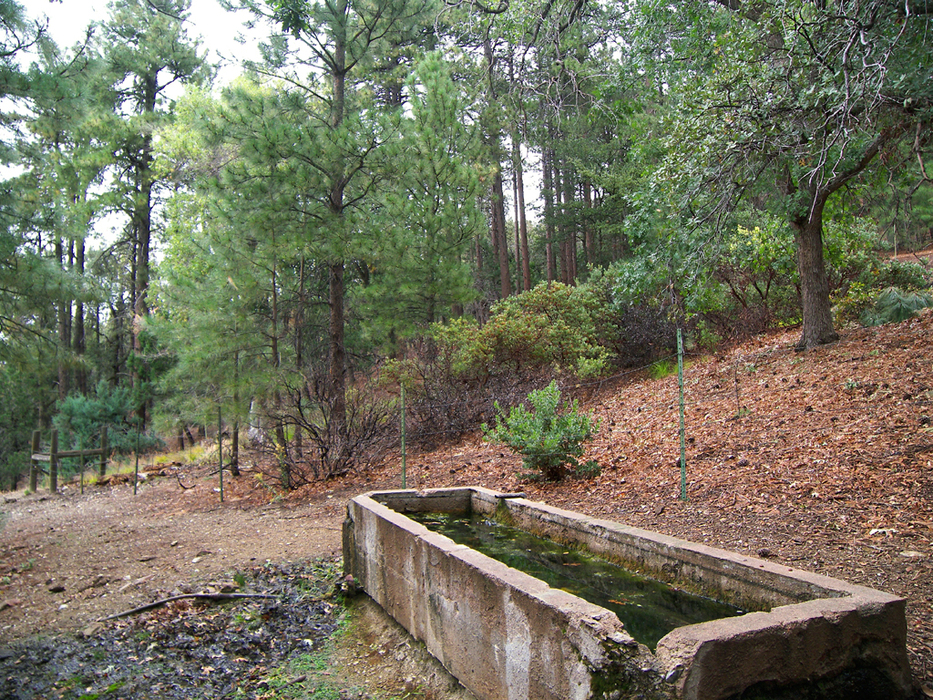
like Gilligan to the Skipper by PrestonSands   Overview: Little Mount Ord, like its loftier neighbor Mount Ord, keeps watch over the Beeline Highway in the center of the Mazatzal Mountains. On this hike, you will find wonderful views and an easy peak bag. The hike makes use of a deteriorated Forest Service road, #1688, and a short off-trail stretch to bring you to the 6114-foot summit of Little Mount Ord. Although the 1688 road can be driven by a four-wheel-drive vehicle, doing so will likely remove a large amount of paint from your vehicle. Overview: Little Mount Ord, like its loftier neighbor Mount Ord, keeps watch over the Beeline Highway in the center of the Mazatzal Mountains. On this hike, you will find wonderful views and an easy peak bag. The hike makes use of a deteriorated Forest Service road, #1688, and a short off-trail stretch to bring you to the 6114-foot summit of Little Mount Ord. Although the 1688 road can be driven by a four-wheel-drive vehicle, doing so will likely remove a large amount of paint from your vehicle.Hike: The hike begins at a small saddle along Forest Road #626, where Forest Road #1688 (signed) joins from the south. Begin hiking south along Forest Road #1688, which immediately passes an old cattle loading chute and enters a pine forest. At 0.1 miles is Colcord Spring, which consists of a concrete water trough above the road on the left. Just beyond the spring, the road crosses a moist drainage of sycamores and grapevines, then makes a hard right to wrap around a broad, brushy ridge, where Mount Ord and Little Mount Ord come into view. After steadily climbing through thick oak brush, the road reaches a saddle and campsite at 0.6 miles.
At 1.6 miles, Forest Road #1688, which is more of an ATV trail at this point, turns west onto the ridge connecting Mount Ord to Little Mount Ord and arrives at a large saddle and turnaround at 1.8 miles. The rounded summit of Little Mount Ord rises on the north side of the saddle. At the turnaround, leave the road behind and head northwest towards the summit, staying high on the brushy ridgeline. At 2.0 miles, the hike reaches Little Mount Ord's brush and juniper-covered summit, where one can enjoy outstanding views of the Mazatzal Mountains, Sunflower, and the distant Phoenix valley. Return the way you came. Check out the Official Route and Triplogs. Leave No Trace and +Add a Triplog after your hike to support this local community. | |||||||||||||||||||||||||||||||||||||||||||||||||||||||||||||||||||||||||||||||||||||||||||||||||||||||||||||||||||||||||||||||||||||||||||||||||||||||||||||||||||||||||||||||||||||||||||||||||||


